The Upper Grist Mill
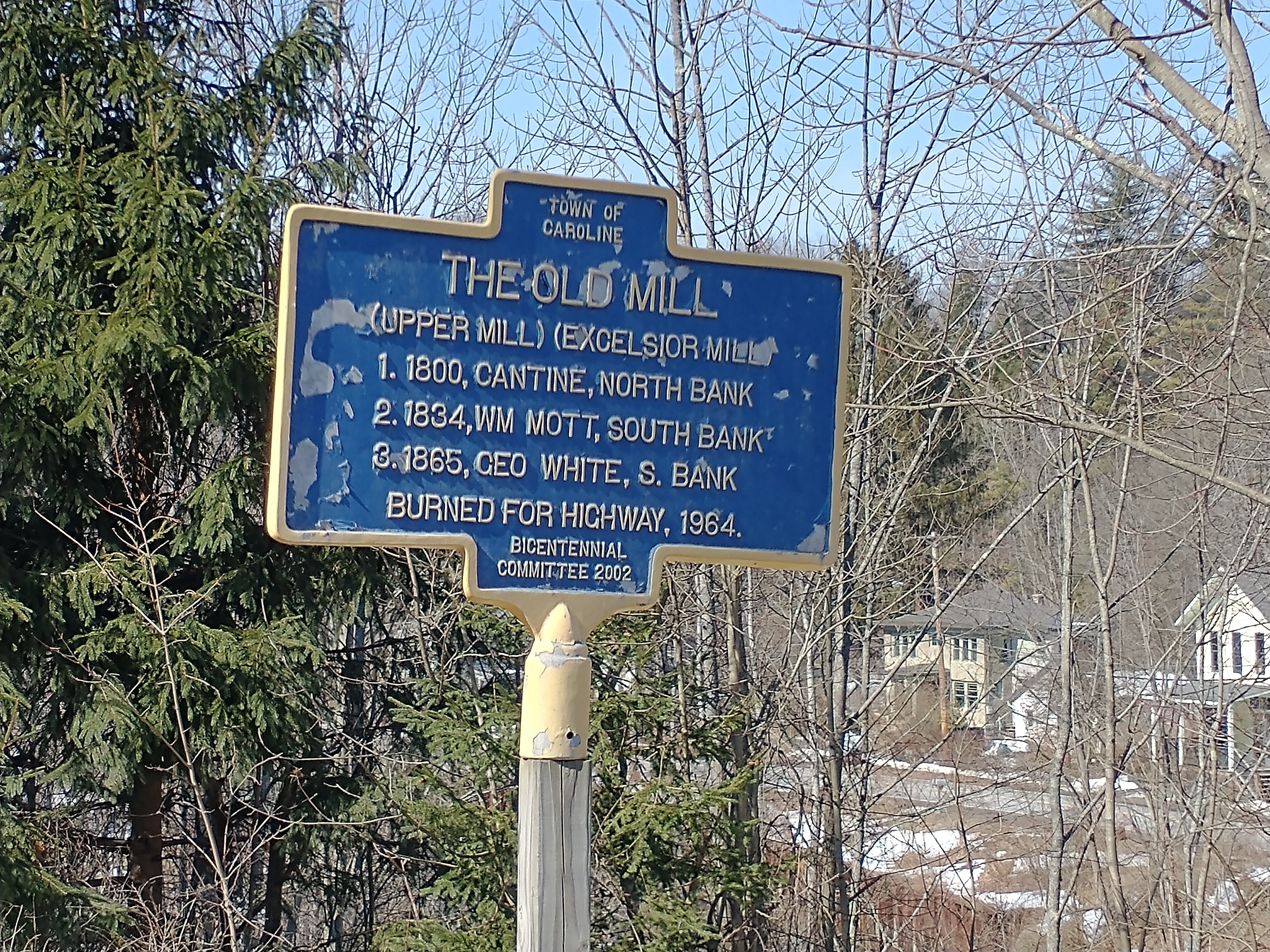
The deed history for the “Upper Grist Mill” can be followed back from the current address of 7 Mill Street, Tax Map ID: 10.-6-8. The land that the mill sat on was appropriated from that parcel by the State of New York in 1963, with the “practice burn” of the mill taking place in 1964. The historical deeds refer to the Upper Grist Mill as the “Motts Mill Property”.

Town of Caroline
The Old Mill
(Upper Mill) (Excelsior Mill)
1800, Cantine, North Bank
1834, Wm. Mott, South Bank
1865, Geo White, S. Bank
Burned for Highway, 1964.
Bicentennial Committee 2002
— 10 Mar 2021, Adam Smith. View largest available size.
The building of the early mills at this point determined its locality as a site for a village. The Upper Grist Mill, as it has been known, stands nearly opposite the site of the old Cantine Mill, which was built about the year 1800, and was burned in 1862, while owned by Joseph Chambers. The present mill was built by George White in 1865, and was sold by him to F. C. Cornell. This mill is not now running. It was at one time owned by William Mott 2d, as was also the mill on the present Voorhis site several years previous. The latter mill was destroyed by fire and rebuilt by David C. Roe in 1850. It passed through several hands to the Voorhises, father and sons, and was burnt in 1890 or 91. Fred E. Bates then became proprietor of the site and built thereon the present mill, and very soon after resold it to the Voorhis brothers. Daniel M. White and Fred E. Bates have two saw mills here.
— 1894, Landmarks of Tompkins County, New York Including a History of Cornell University by Prof. W.T. Hewitt, edited by John H. Selkreg, D. Mason & Company, Syracuse NY, p291.
Beginning with the oldest deed I have yet found, 01 Dec 1864, Caroline Deeds book 1, page 266, the original parcel that the Upper Grist Mill sat upon was “supposed to contain ten acres of land upon which is situated the grist mill, plaster mill, saw mill, dwelling house, orchard and Blacksmith Shop”. This would seem to indicate that the “S & G Mill” noted on the 1866 map of Mott’s Corners from the Photographic Atlas of Tompkins County, New York, Stone & Stewart, Philadelphia, p21, stands for “Saw and Grist Mill”. The very next deed less than a year later on 26 Aug 1865, Caroline Deeds book 1, page 330 adds to the list “hay scales” and “all that remains of the grist mill of wood, stone, and cast and wrought iron, and the same of the plaster mill”, seemingly indirectly referring to the earlier fire.
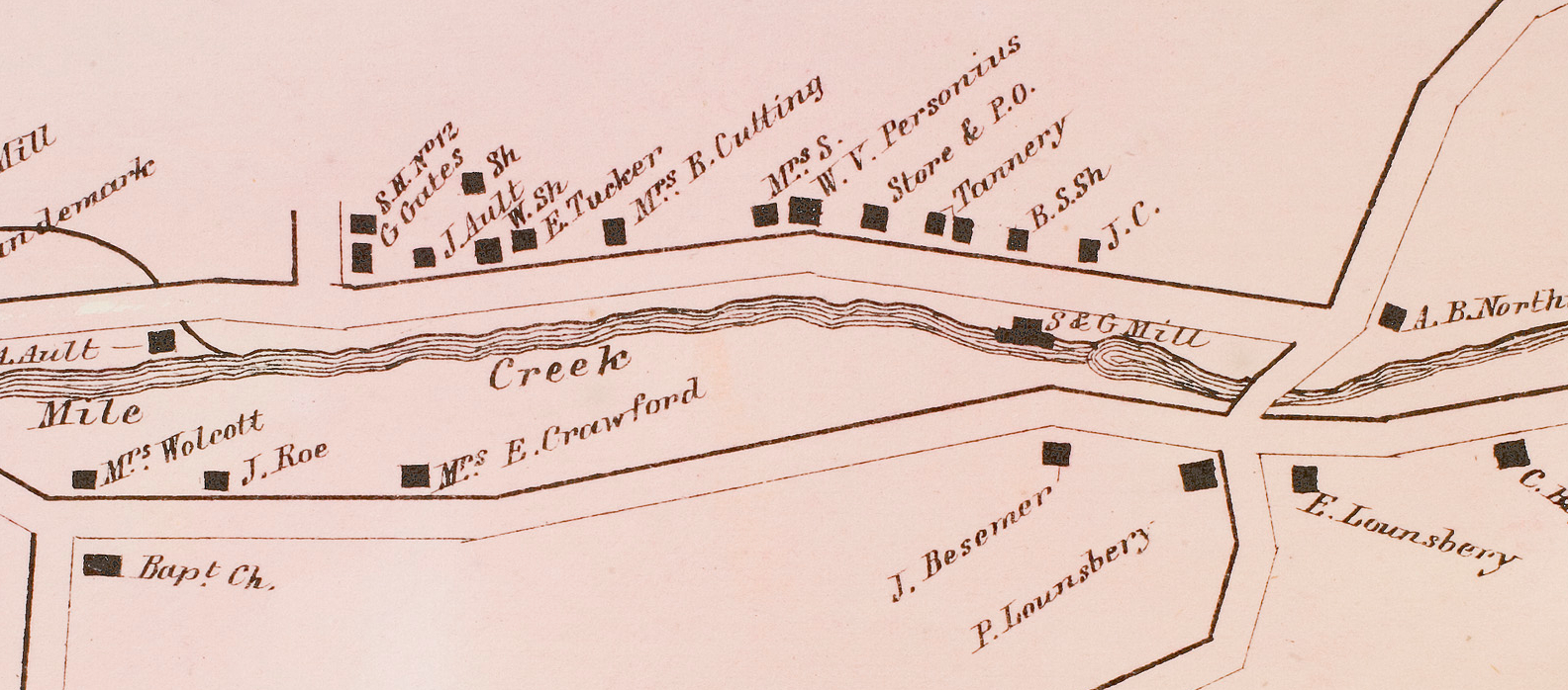
The 1866 Stone and Stewart map of Mott’s Corners depicts the “S&G Mill” on the north bank of Six Mile Creek, and depicts the nearby Blacksmith Shop and other landmarks mentioned in the deeds including the upper bridge and the “new Baptist Church”.
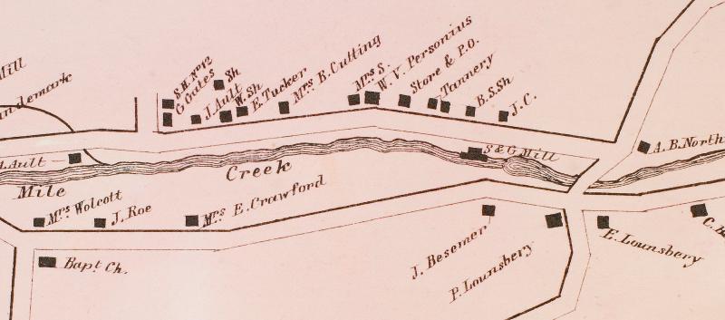
— 1866, Photographic Atlas of Tompkins County, New York. Stone & Stewart, Philadelphia, p21. Cropped and rotated. View largest available size.
A 1963 survey survey map shows the “Old Mill” on the south bank of Six Mile Creek, along with a small bridge where Mill Road ends. As I write this, the abutments for the Mill Road bridge, as well as some of the grist mill foundation can still be seen.
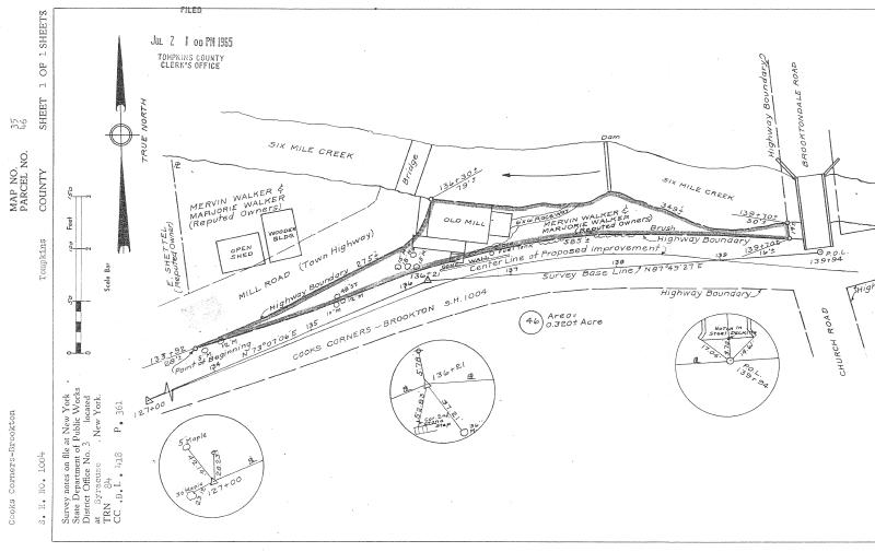
— 30 Sep 1963, Map 35, Parcel 46, Tompkins County Clerk, Ithaca NY. View largest available size.
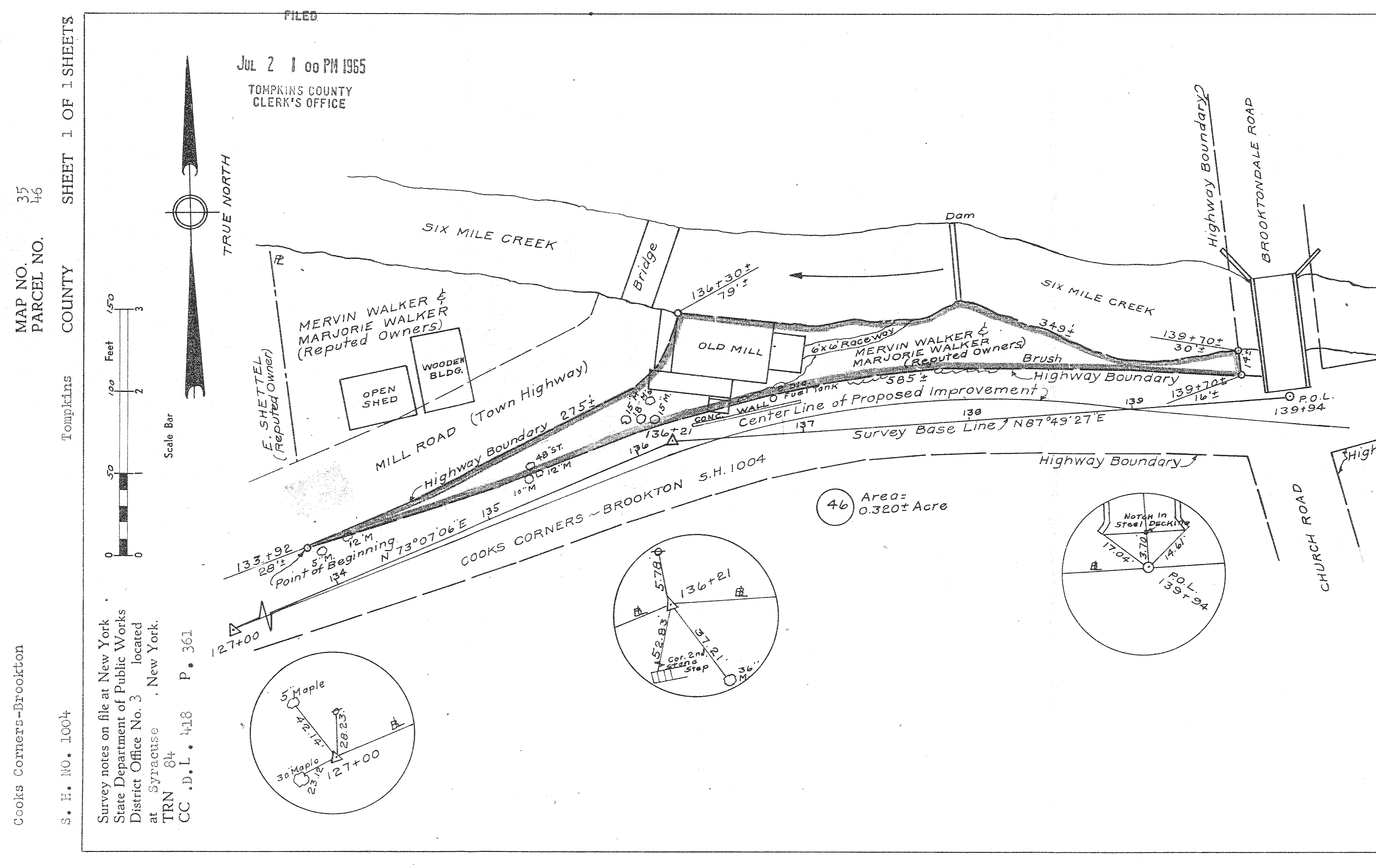
On 13 Dec 1870 the property was purchased by Franklin Cuthbert Cornell Sr. (28 Aug 1837 to 22 Jan 1908), the eldest son of Ezra Cornell (11 Jan 1807 to 09 Dec 1874), the founder of Cornell University. When Frank C. Cornell sold the property to George Campbell, Caroline Deeds book 3, page 550, 21 May 1881, a “piece of land” was reserved for Edward Lounsbery (11 Oct 1833 to 27 Nov 1904) and George E. Sanders (16 Aug 1847 to 01 Nov 1889), which seems to corroborate a Carl English painting that refers to a tannery near the upper mill, although the deeds only refer to it as a “factory”. George E. Sanders is listed as “tanner” in the 1875 NY State Census after selling the building that housed his father’s general store to Edward Lounsbery the same year.
The deeds seem to indicate that what is presently Valley Road near the old mill site and the upper bridge, was called “Mechanic’s Road”. Similarly, what is presently Lounsbery Road (and possibly including what is presently White Church Road) was called “Hoffman Road”.
Benjamin F. Hoffman (? to 28 Feb 1866) married Susan Maria (Snow) Cantine Hoffman (09 Oct 1819 to 18 Sep 1898) whose first husband was Charles Cantine Jr. (08 May 1814 to 23 Aug 1845) the son of Charles Cantine (23 Sep 1771 to 20 Dec 1831).
The HOFFMAN TAVERN is mentioned in an article about early Brooktondale by Cantine Lounsbery. He said that Benjamin Hoffman had a log tavern, near where now stands the Honor Roll on White Church Road, before Peter Lounsbery built his house in 1820.
— 1994, A History of the Town of Caroline Tompkins County, New York United States of America, (the “Bicentennial Book”), Revised and Compiled by Barbara B. M. Kone, Town of Caroline Historian, p118.
Charles Cantine Jr.’s sister Harriet (Cantine) Lounsbery (06 Nov 1801 to 17 Jul 1880) married Peter Lounsbery (12 May 1797 to 04 Apr 1867) on 21 Jun 1824 in Marbletown NY. The earliest deeds state that the Motts Mill Property was “part of the farm whereof Charles Cantine senior died”, and is “land conveyed by will from Charles Cantine to his daughter Harriet”. Peter Lounsbery’s name appears on these deeds in his role as Justice of the Peace.
Peter and Harriet’s large family included Edward Lounsbery, mentioned above, a tanner, currier and “hide dealer”, and a Civil War veteran, who helped found the Congregational Church of Mott's Corners, the High Bridge Lodge of the Independent Order of Good Templars, and the David Ireland Post of the GAR. Edward Lounsbery owned both Mills' store and Mills' home, among other properties.
A partial summary of the Upper Mill deeds:
| Book | Book num | Page num | Document date | Recorded date | Grantor | Grantee |
|---|---|---|---|---|---|---|
| Deeds | 759 | 321 | 13 Oct 1995 | 16 Oct 1995 | Claire E. Shettel/Prescott | Frank G. Eggleston |
| Deeds | 759 | 322 | 26 May 1995 | 16 Oct 1995 | Claire E. Shettel/Prescott | Frank G. Eggleston |
| Deeds | 497 | 214 | 01 Nov 1971 | 23 Nov 1971 | Marjorie E. Walker | Claire E. Shettel |
| Deeds | 457 | 667 | 02 Jul 1965 | 02 Jul 1965 | Mervin & Marjorie Walker, Harry C. & Carina M. Whitlock, New York State Electric & Gass (NYSEG) | State of New York |
| Maps | 35 | 46 | 30 Sep 1963 | 02 Jul 1965 | Mervin & Marjorie Walker, Harry C. & Carina M. Whitlock, New York State Electric & Gass (NYSEG) | State of New York |
| Deeds | 418 | 361 | 10 Jul 1959 | 10 Jul 1959 | Harry C. & Carina M. Whitlock | Mervin & Marjorie Walker |
| Deeds | 200 | 151 | 03 Dec 1921 | 29 Nov 1921 | Edward F. Vorhis, Edna Vorhis and Charles W. Van DeMark as Executors of Frank C. Vorhis. | Harry C. Whitlock |
| Deeds | 198 | 480 | 19 May 1921 | 08 Nov 1921 | Edward F. & Maude E. Vorhis, F. Alida Vorhis, E. Grace Vorhis, Edna Vorhis | Edna Vorhis, Edward F. Vorhis & C. W. Van Dermark, executors of last will and testament of Frank C. Vorhis, deceased. |
| Deeds | 160 | 270 | 14 Apr 1903 | 01 Feb 1904 | Benjamin & Mabel Rightmyer, Roxana Rightmyer, Loretta Hendrickson Van Wort, Andrew Rightmyer, heirs of John Rightmeyer | Frank C. Vorhis |
| Deeds | 140 | 513 | 11 Dec 1893 | 02 Jan 1894 | George & Martha Campbell | John Rightmyyer |
| Caroline Deeds | 3 | 550 | 21 May 1881 | 24 May 1881 | Franklin C. Cornell | George Campbell |
| Caroline Deeds | 3 | 36 | 13 Dec 1870 | 15 Dec 1870 | George W. White | Frank C. Cornell |
| Caroline Deeds | 1 | 364 | 27 Jan 1866 | 02 Feb 1867 | Miles Landon | George W. White |
| Caroline Deeds | 1 | 330 | 28 Nov 1865 | 01 Dec 1865 | Jacob G. Chambers | Miles Landon |
| Caroline Deeds | 1 | 267 | 26 Aug 1865 | 08 Sep 1865 | Benjamin F. Hoffman | Jacob G. Chambers |
| Caroline Deeds | 1 | 266 | 01 Dec 1864 | 08 Sep 1865 | Josiah and Mary A. Besemer | Benjamin F. Hoffman |
— 7 Mill Street, Brooktondale NY, Tompkins County Clerk, Ithaca NY. Click column headers to change sort order. Download source data.
…the abandoned upper mill was subjected to a spectacular “practice burn” in the summer of 1964…
— Molly Adams, “Town of Caroline” in The Towns of Tompkins County: From Podunk to the Magnetic Springs edited by Jane Marsh Dieckmann, p69.