The Mill Race Bridge and The Barn
In the 1860’s, when Brooktondale was called Mott’s Corners, and Brooktondale Road was called Creek Road, the lower grist mill that was known for a time as Personius Flouring Mills sat where Dalebrook Apartments sit presently, almost directly across the street from Mills’ Store, a building better known to many today as “The Old Post Office”. What would later become known as “The Mills’ Place” was sub-divided from the grist mill property, and it was originally referred to as “The Wolcott Lot” for William Benton Wolcott, the first owner of record. The Mill Race Bridge is one of the primary landmarks used to establish the Place of Beginning for the Mills’ Home parcel from the time of its original sub-division from the grist mill to the end of Emily Mills’ life. This section attempts to accurately locate the Mill Race Bridge and describe its shape and size.
“Being a part of the grist mill lot…beginning in the center of the Creek Road eighty-two links easterly from the center of the bridge crossing the Mill race…”
“As a young boy, [Carl English] and his brother had been part of a work crew hired to fill in the creek / stream that ran from the mill pond (between you and the Dalebrook)…across B’dale Rd…through what’s now an empty field between the Andersson’s and the Todi’s property….into Six Mile Creek. There was a bridge near 475 giving it the nickname “bridge’s house” or something like that. This fill-in, while successful, resulted in fairly unstable land.”
Introducing The Grist Mill Raceway and the Tailrace Bridge
For a long time, I have wanted to know more about the location and size of the Mill Race Bridge, to re-envision this aspect of Emily’s world and better understand the history of the property. The members of the Mills household would need to cross the Mill Race Bridge, either by foot or wagon, to get to their store and the Congregational Church from their home. The original wooden bridge must have amplified the sounds of carriages and wagons passing over it.
I will examine the available documentary evidence that directly references the mill raceway and bridge, and I will also add historical context that may aid interpretation of that evidence, beginning with some of the historical deeds for the grist mill/Dalebrook property during the relevant time period that will be discussed.
| Book | Book num | Page num | Document date | Recorded date | Grantor | Grantee | Amount |
|---|---|---|---|---|---|---|---|
| Caroline Deeds | 2 | 510 | 01 Jan 1877 | 02 Jan 1877 | Charles W. Personius | A. C. Vorhis & Wm. R. Vorhis | |
| Deeds | 198 | 201 | 08 Nov 1920 | 17 Nov 1920 | Edward R. Vorhis et al. | Benjamin F. Lockwood | |
| Deeds | 235 | 85 | 03 Jul 1934 | 05 Jul 1934 | Mittie A. Lockwood et al. | Elmer L. Lockwood et al. | |
| Deeds | 184 | 378 | 01 Nov 1945 | 16 Feb 1946 | Elmer L Lockwood and Clara T. Lockwood | Charles C. Vorhis | |
| Deeds | 499 | 981 | 27 Apr 1972 | 08 May 1972 | Charles C. Vorhis | Frank P. Proto and Almita Ann Proto |
— 487 Brooktondale Road, Brooktondale NY, Tompkins County Clerk, Ithaca NY. Click column headers to change sort order. Download source data.
(The historical deeds for Dalebrook and Brookton’s Market, the former lower grist mill and woolen mill respectively, are very complex, in terms of ownership, property lines and water rights to the raceway, and as a result, the deeds above are simply those I have found so far that I have been able to confirm and which are relevant to the Mills’ property. As time allows, I will try to obtain a more complete and accurate account. [TODO: investigate deeds: Car 1/516, Car 1/518, Car 2/425, 134/69.])
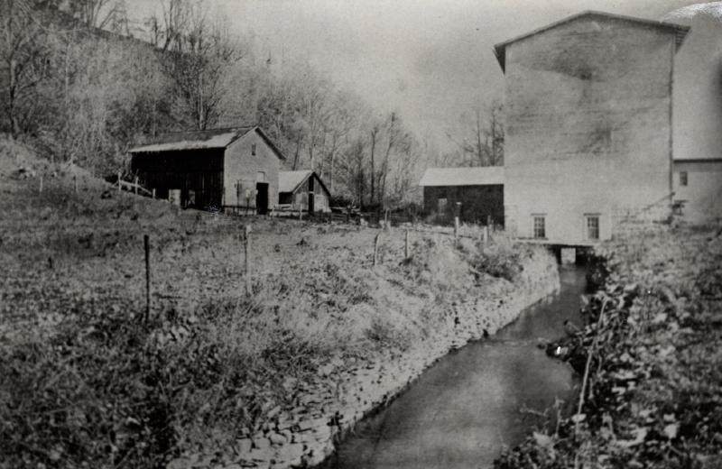
The following photograph shows the lower grist mill after it was rebuilt from the 1890 fire, and likely in the last years before it was dismantled. For more specific information on the mill itself, see The Lower Grist Mill/Dalebrook.
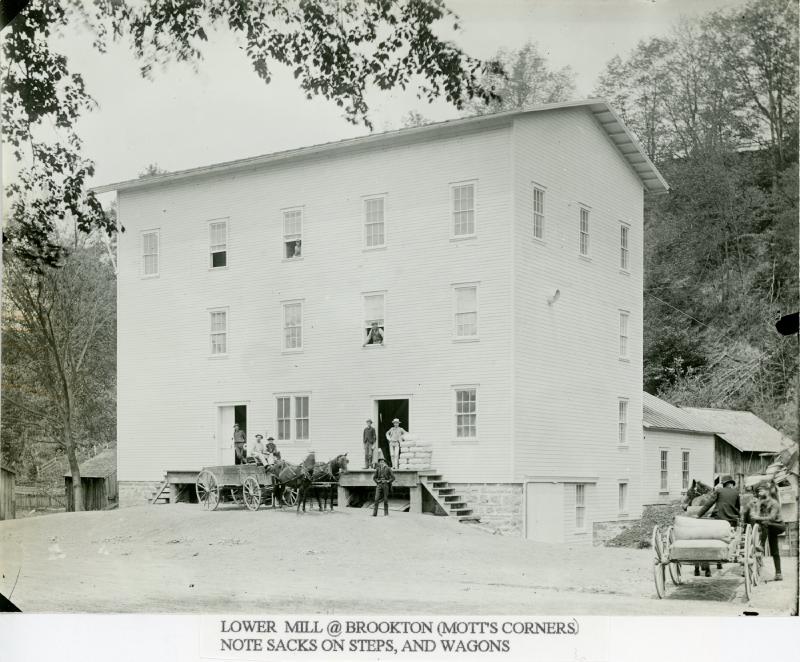
— Caroline History Room, Slaterville Spring NY. View largest available size.
The grist mill was powered by water diverted from Six Mile Creek into a mill pond located behind Mulk’s Store/Brookton’s Market.
A mill race, millrace or millrun, mill lade (Scotland) or mill leat (Southwest England) is the current of water that turns a water wheel, or the channel (sluice) conducting water to or from a water wheel. Compared with the broad waters of a mill pond, the narrow current is swift and powerful. The race leading to the water wheel on a wide stream or mill pond is called the head race (or headrace), and the race leading away from the wheel is called the tail race (or tailrace).
– Mill race, Wikipedia.org.
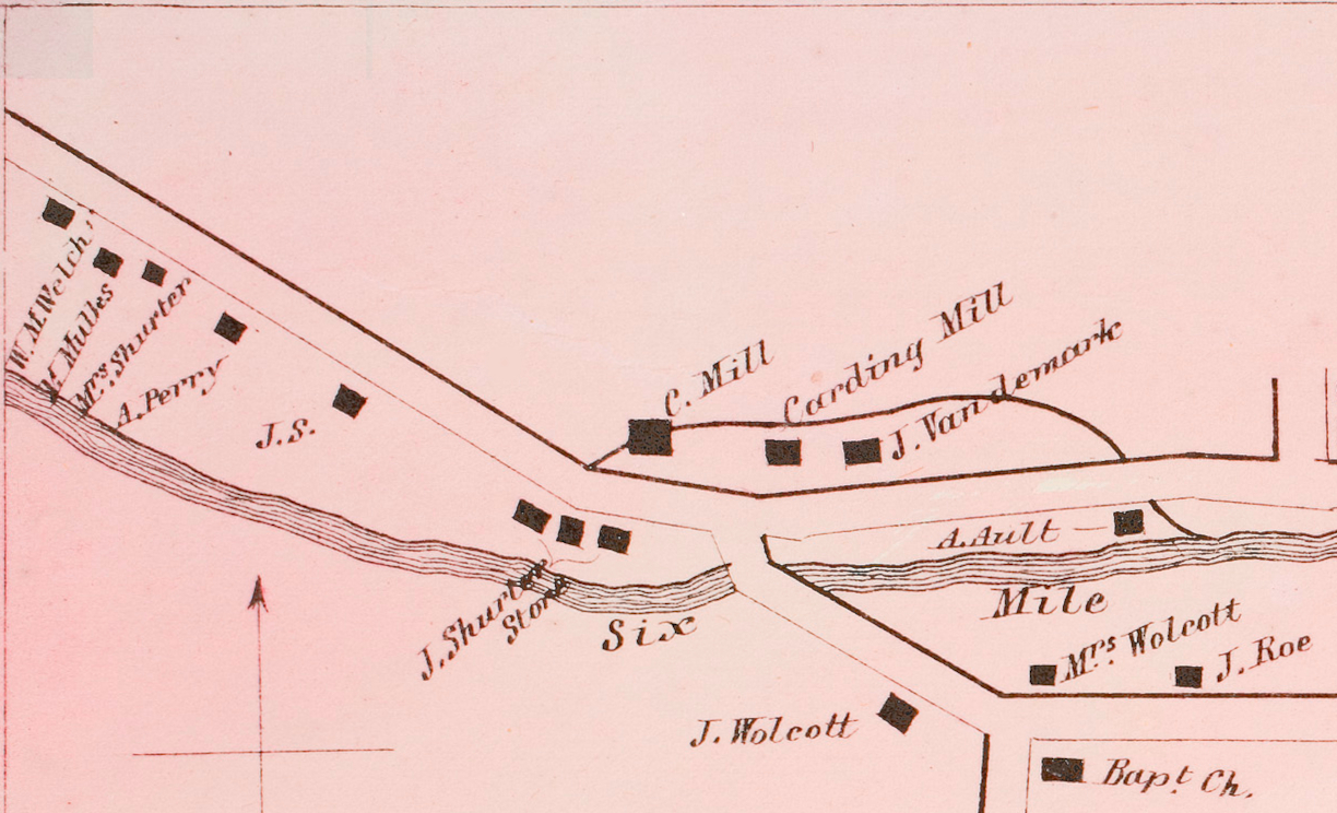
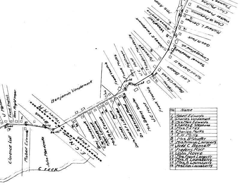
In the 1866 Photographic Atlas of Tompkins County by Stone & Stewart, part of the mill raceway is represented, from its origin at Six Mile Creek up to the point that it intersects with Creek Road on its return to Six Mile Creek.
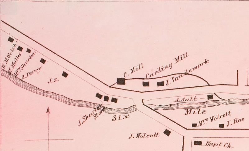
— 1866, Photographic Atlas of Tompkins County, New York. Stone & Stewart, Philadelphia, p21. Cropped and highlighted in red. View largest available size.
The map was obviously drawn some time before its 1866 publication date, so the absence of Mills’ Home is not necessarily inconsistent with its purported construction in 1865.
The portion of the raceway that crosses Mills’ Home is the grist mill tailrace, and is either directly referenced as such, or descriptively referenced as the race that exits the grist mill. There is obviously a corresponding bridge across the mill headrace on the portion of Brooktondale Road (as it is presently designated) to the east of the grist mill, the portion that was known at different times in the past as “Back Road”, “Easy Street”, and “Creek Road”. The historical deeds of the relevant properties in that area also reference this bridge, often simply generically as “the mill race bridge”, not specifying its relative position either directly or descriptively as was done with the tailrace bridge. Descriptions of the headrace bridge will be near School House Road, what I know as Vandemark Road.
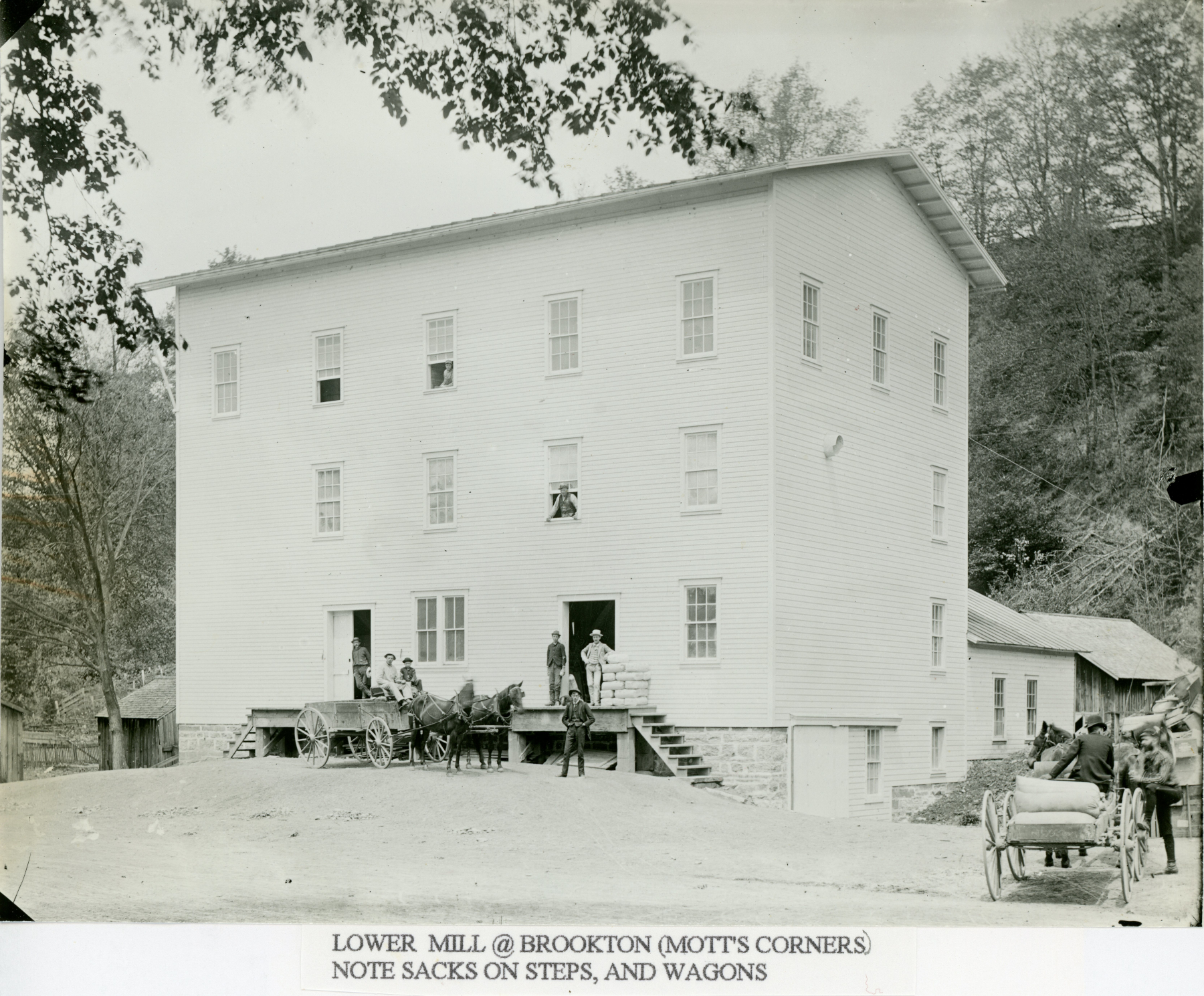
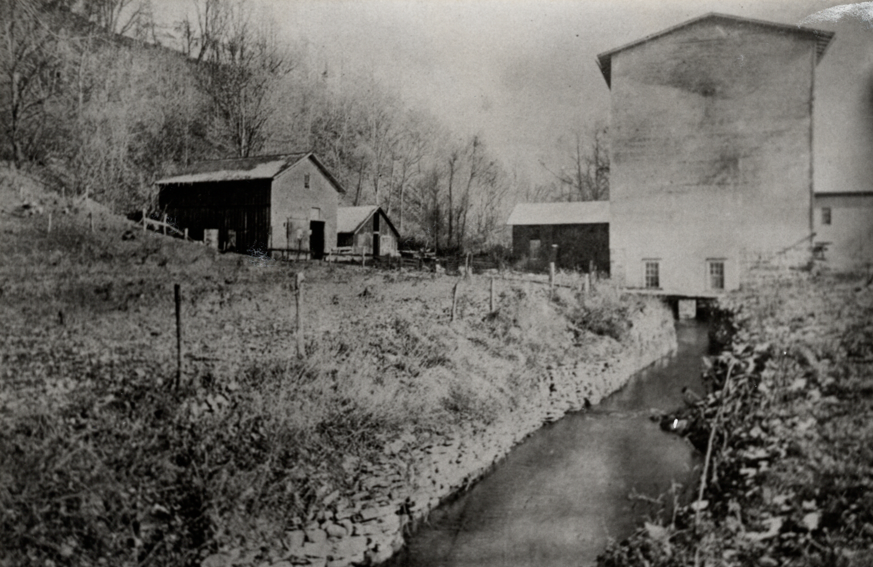
The following is the only photograph of which I am aware that shows the lower grist mill tailrace, taken sometime after the mill was rebuilt from the 1890 fire, and likely before 1900.
— Caroline History Room, Slaterville Spring NY. View largest available size.
The headrace fed into the mill pond behind Mulks’ Store, presently Brookton’s Market. I have seen a photograph of the grist mill and store that shows water flowing out of the pond into the grist mill. According to A Drive-by Tour of the Town of Caroline sponsored by the Town of Caroline Bicentennial Committee 1994-1995, and corroborated by other accounts, there were three mills on the site of Dalebrook, all of which apparently burned. Also in the past, there was a plaster mill and a woolen mill directly next to the grist mill property to the east. Throughout the historical deeds for these properties, access to water rights are explicitly reserved for each.
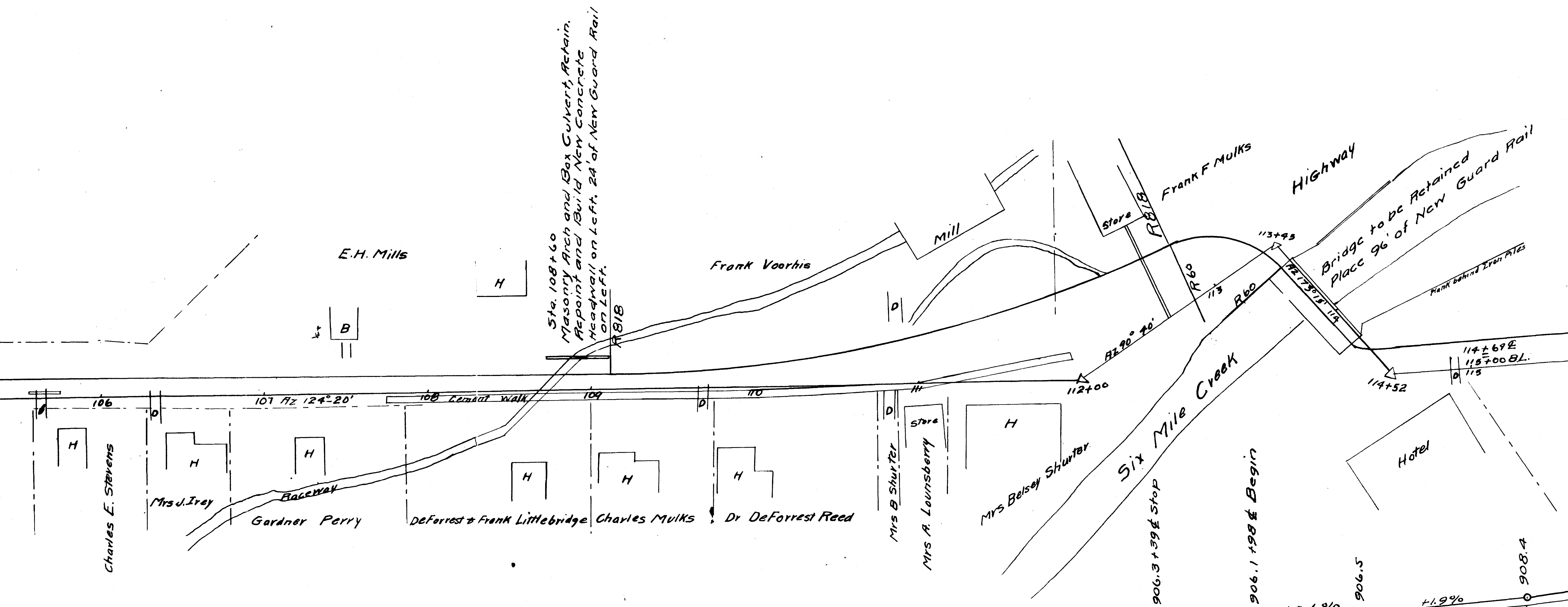
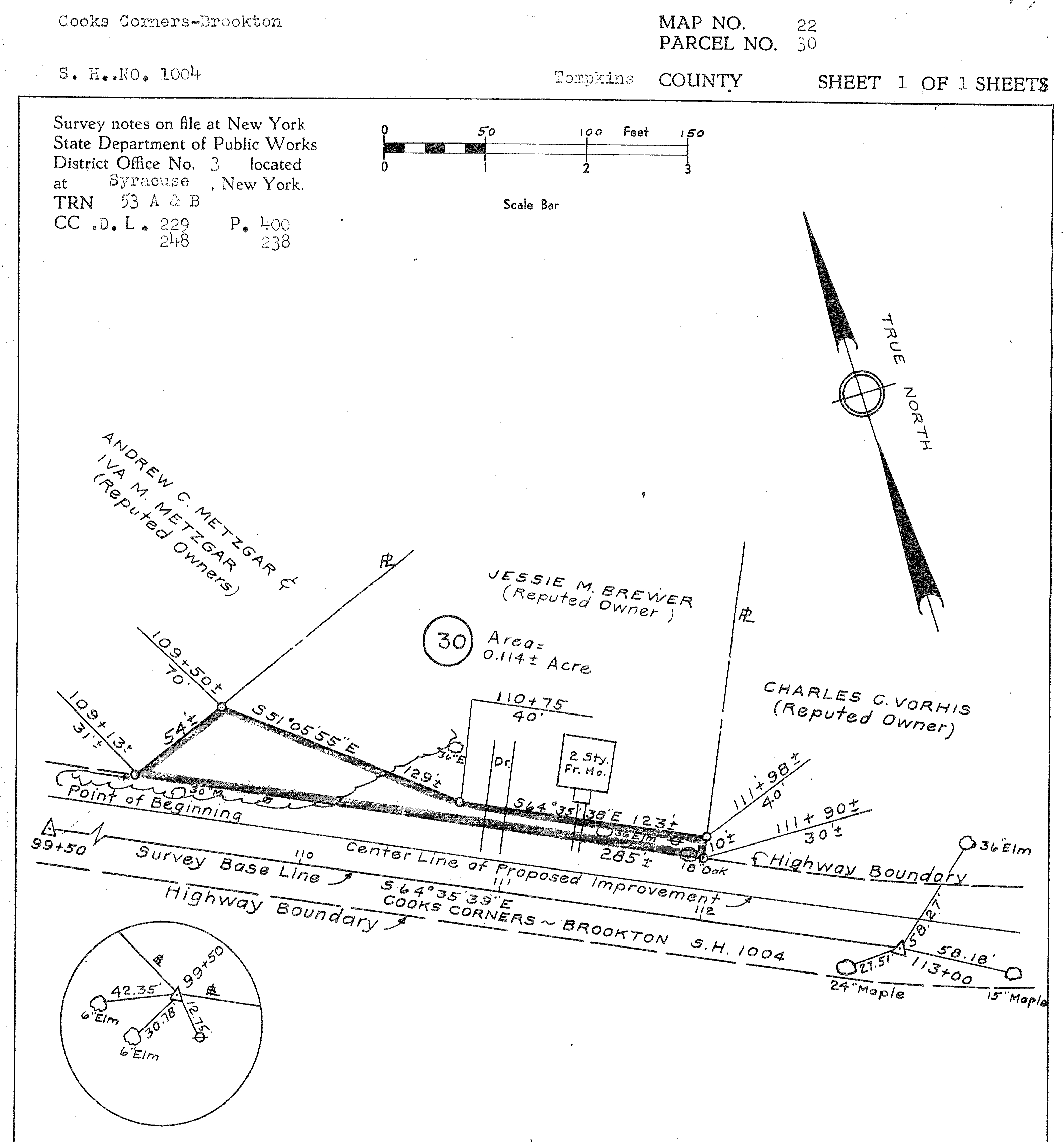
A collection of Tompkins County highway maps published in 1912 depict the course of the mill raceway in more detail, including what may be a visual representation of the Mill Race Bridge, and if this interpretation is correct, then it is the only visual representation of the Mill Race Bridge of which I am aware. This and other maps in the 1912 series still list the owner of Mills’ Home as E. H. Mills, which can be explained by the fact that John Mandeville’s obituary describes the surveyors working in 1907, while Edward was still alive. These maps also depict the Brookton Trestle, on at least two maps.
— 26 Feb 1912, Plans for Improving the Cooks Corners-Brookton: Slaterville Springs-Caroline County Highway, Instrument number BF033282-001, Sheet 1, Tompkins County Clerk, Ithaca NY. Cropped. View largest available size.
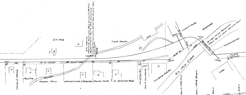
— 26 Feb 1912, Plans for Improving the Cooks Corners-Brookton: Slaterville Springs-Caroline County Highway, Instrument number BF033282-001, Sheet 5, Tompkins County Clerk, Ithaca NY. Cropped. View largest available size.
When I initially envisioned the mill race crossing Brooktondale Road, I assumed that it would do so perpendicular to the road, thus simplifying the bridge infrastructure needed. I imagined a rather small channel for the tailrace and assumed that the Mill Race Bridge was probably a modest structure. So, I was surprised to see it depicted as flowing across the road at an angle, requiring a much more substantial structure to span even a small channel. However, ground penetrating radar scans done in 2023 corroborate that the course of the raceway in 1912 (at the end of the raceway’s existence) flowed to the southwest across the road, at an angle that I would visually estimate is less than 45 degrees relative to the road.
And a more substantial bridge makes sense from other data points, such as its choice as a landmark defining the Place of Beginning in the deed descriptions of 1869 and 1883, and Andrea Talmage’s recollections of her conversation with Carl English, referenced in full further below, in which he told her that the mill race bridge gave Mills’ Home “the nickname ‘bridge’s house’ or something like that”.
I believe the angled, southwest course of the raceway under the road can be explained by a few factors. First, understand that Dalebrook has a basement that is at ground level, but Frank Proto has told me that the mill infrastructure itself is in a sub-basement of the building, and so, it is from the sub-basement that the raceway emerges, and in the middle of the western side of the Dalebrook foundation, a grill recessed in the ground still exists as I write this as evidence of this past configuration.
(It should be noted however, that as I recall Frank explaining to me, the functional areas of the former mill are currently inaccessible behind a concrete wall, and he has never seen that area himself.)
Consulting a current topographical map shows what is evident to my naked eye, that the slope of the ground over this portion of the raceway is very gradual. Note that a topographical line falls across the approximate area of former southern edge of the raceway behind Brookton’s Market, but otherwise, this topographical map indicates the land from the western side of Brookton’s Market to past the point of Todi’s fence, completely encompassing the mill tailrace in the area being considered and for a large area around it, descends less than ten feet:
— 02 Jul 2023, Environmental Resource Mapper, New York State Department of Environmental Conservation, gisservices.dec.ny.gov. View largest available size.
The topography suggests to me that a possible reason for why the raceway was apparently built to follow a gradual southwest diagonal course under the road: over a shallow grade, a straighter course offers less resistance to the flow of water. Perhaps straightening the turn at the road would also have benefits from an engineering standpoint, despite the larger bridge infrastructure needed.
In fact, as I write this, Six Mile Creek itself crosses Brooktondale Road diagonally, as multiple maps, including the topographical map, as well as photographs, including two presented further below, all attest. It wasn’t always this way, and I will explain that further on.
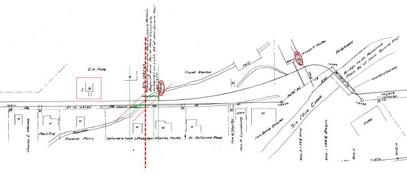
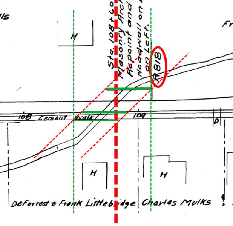
Although I was initially tempted to believe that the 1912 highway survey shows the eastern property boundary of Mills’ Home aligning with the end of the Mill Race Bridge, which could help derive an estimate for the span of the bridge, it appears that this line, labelled “R818”, is not intended to represent the property boundary, at least, not directly. Note that this line is solid like other measurement lines on the map, and it is not dashed like the other property lines shown. Also, there is a line to the east of Mulk’s store with the same label, which seems to indicate a relationship between the two lines that I admittedly don’t fully understand currently, but which could perhaps be reasonably accurately measured today to provide further insight into Mill Race Bridge’s position. Regardless, it seems that the shared boundary line designating the eastern edge of Mills’ Home and the western edge of Dalebrook is not represented on the 1912 highway survey.
The “R818” is Radius 818 feet at the beginning of the curve, just the other side of the “store” is a reverse curve ending the Radius of 818’ to the Left and beginning Radius of 60’ to the Right. That being said it answers the next question: this line does not represent the boundary line. This map does not show this property line at all. The property lines between land owners shown on this map and most all highway maps are to be taken as “approximate” because highway maps are mapping the “highway” and any land needed for appropriations for highway purposes and do not do all the work necessary to determine the boundaries of the land owners. Most are shown per lines of “occupation”.
— 17 Feb 2023, Ian Sheive, Sheive Land Surveying, personal correspondence.
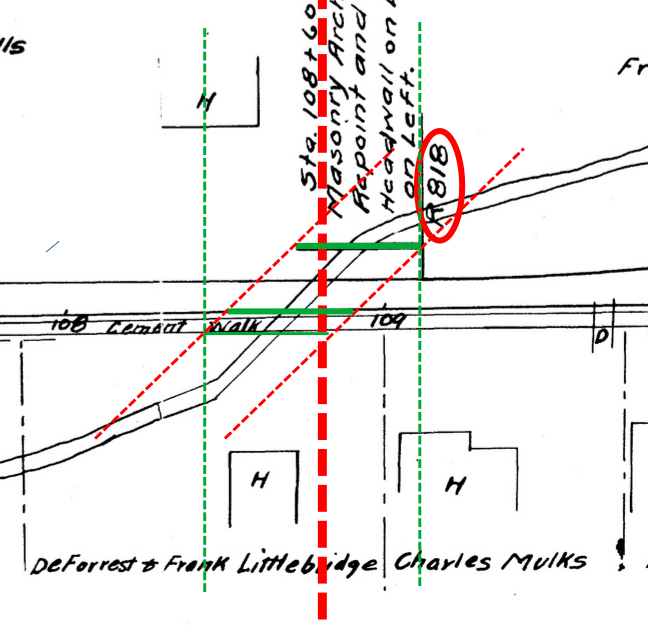
The next logical question in my mind was about the bridge design: would it have been built at a diagonal, simply following the course of the raceway channel and having offset guard rails, as depicted with the solid, horizontal green lines below, or would it be squared up, so that the abutments on each side fell on lines perpendicular to the road, as depicted with the vertical dashed green lines below. The depiction of the diagonal orientation is based on the assumption that the upper guard rail (or some part of the bridge structure) is represented on the map, that I then replicated at the correct angle on the southern edge of the road along with a portion of the bridge over the cement walk that also must have existed. The dashed vertical red line estimates the center of the Mill Race Bridge at the center of Creek Road
— 26 Feb 1912, Plans for Improving the Cooks Corners-Brookton: Slaterville Springs-Caroline County Highway, Instrument number BF033282-001, Sheet 5, Tompkins County Clerk, Ithaca NY. Cropped. View largest available size.
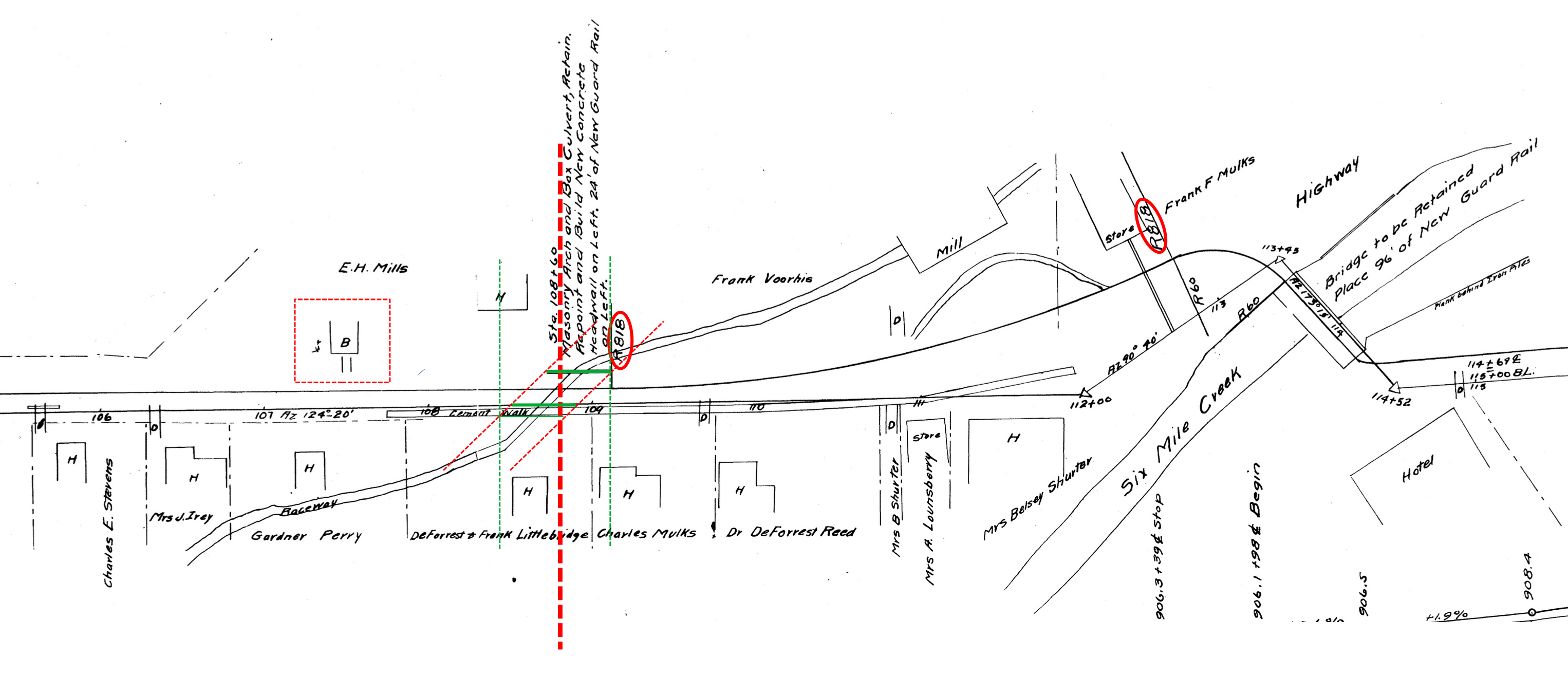
— 26 Feb 1912, Plans for Improving the Cooks Corners-Brookton: Slaterville Springs-Caroline County Highway, Instrument number BF033282-001, Sheet 5, Tompkins County Clerk, Ithaca NY. Cropped. View largest available size.
For now, I will point out that we don’t have to look far for an example of each type of bridge construction, which can both be found in the lower bridge over Six Mile Creek. As evidenced by the 1912 highway map above, and by the photo below, the lower bridge was originally built perpendicular to Six Mile Creek, when what I know as Brooktondale Road and Valley Road were not connected as they are presently.
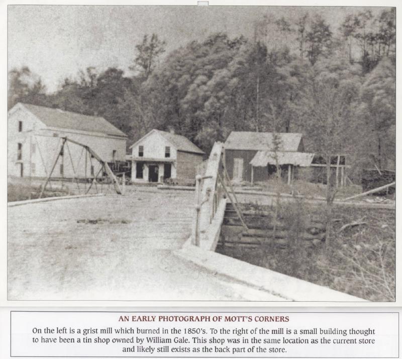
An Early Photograph of Mott’s Corners
On the left is a grist mill which burned in the 1850’s. To the right of the mill is a small building thought to have been a tin ship owned by William Gale. This shop was in the same location as the current store and likely still exists as the back part of the store.
— Jan 2011, Brookton’s Market 2011 Calendar, Compiled by Deborah Halpern and Kathy Keaney. Layout and design by Avi Smith. View largest available size.
This photo was likely taken in the window of time between the first two Mills’ Home deeds that first describe the Mill Race Bridge, based on the purported presence of William Gale’s tin shop, as explained in the section exploring the stone foundation of Mills’ Home
But as I will explore further below, along with photograph showing it, the configuration of the lower bridge changed in the 1960’s, as what are presently named Brooktondale Road and Valley Road, and which had been two visually distinct roads connected by the lower bridge, were joined in such a way as to straighten the course of the roads at the bridge, with the bridge oriented diagonally over the creek and guard rails on each side offset from the bridge center.
But ultimately, because these 1912 maps are highway surveys and not property surveys, and because it is clear that the represented property boundaries and structures were not measured for the purposes of these surveys, I conclude that all property boundaries on the 1912 highway surveys should be interpreted as approximations, as should the placement of physical structures such as dwellings, and the Mill Race Bridge, and even landmarks such as the mill raceway itself. If it is not measured, I assume it is merely illustrative.
So, where exactly was the bridge relative to Mills’ Home? What follows are my best attempts to estimate the location of the mill race bridge based on references to it in historical deeds and associated property survey maps of Mills’ Home and Dalebrook. Essentially, to understand the location of the Mill Race Bridge, one must understand the history of the boundary line shared by Mills’ Home and Dalebrook, which is not straightforward.
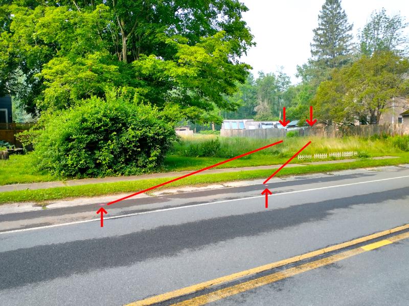
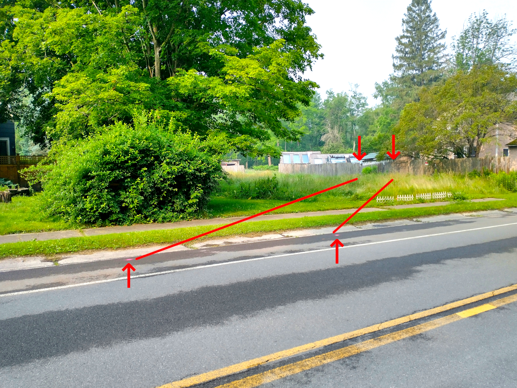
Echoes of the Tailrace
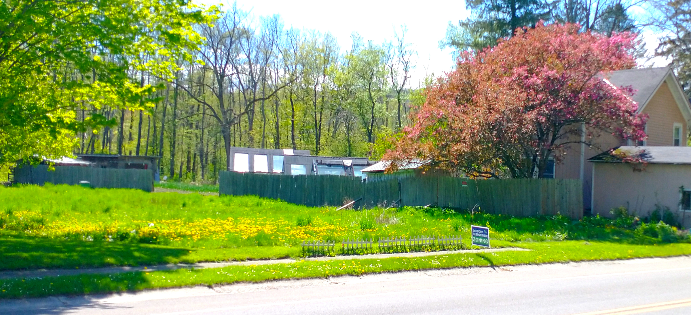
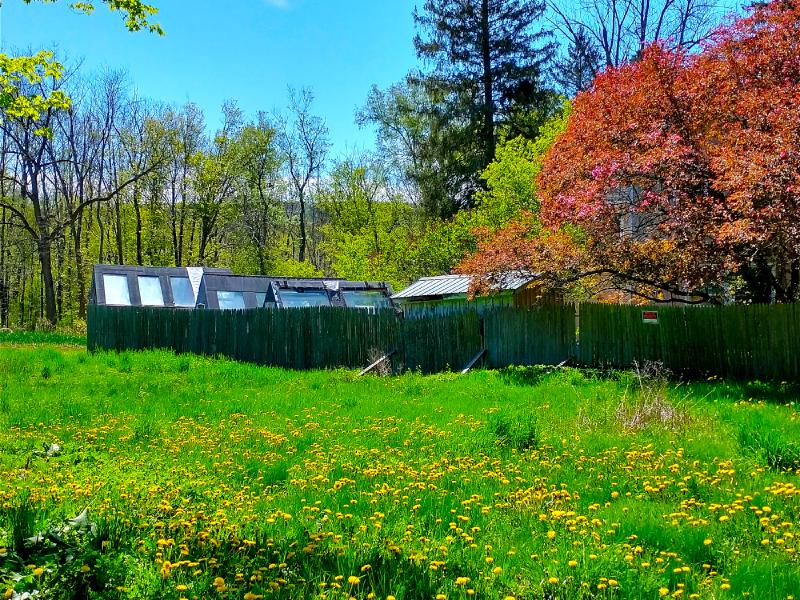
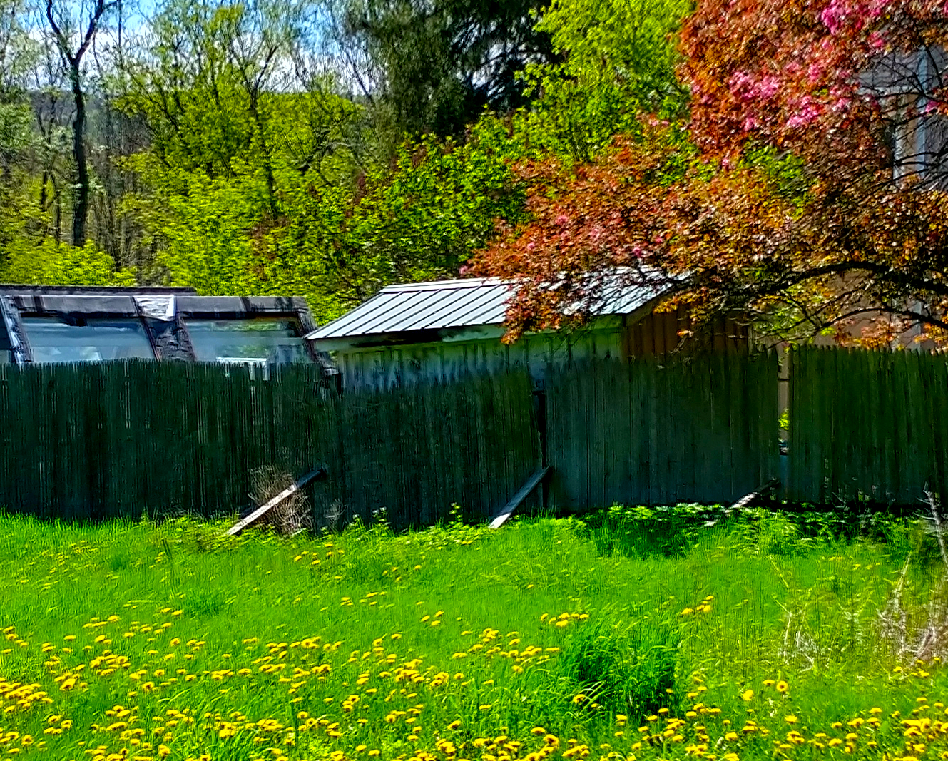
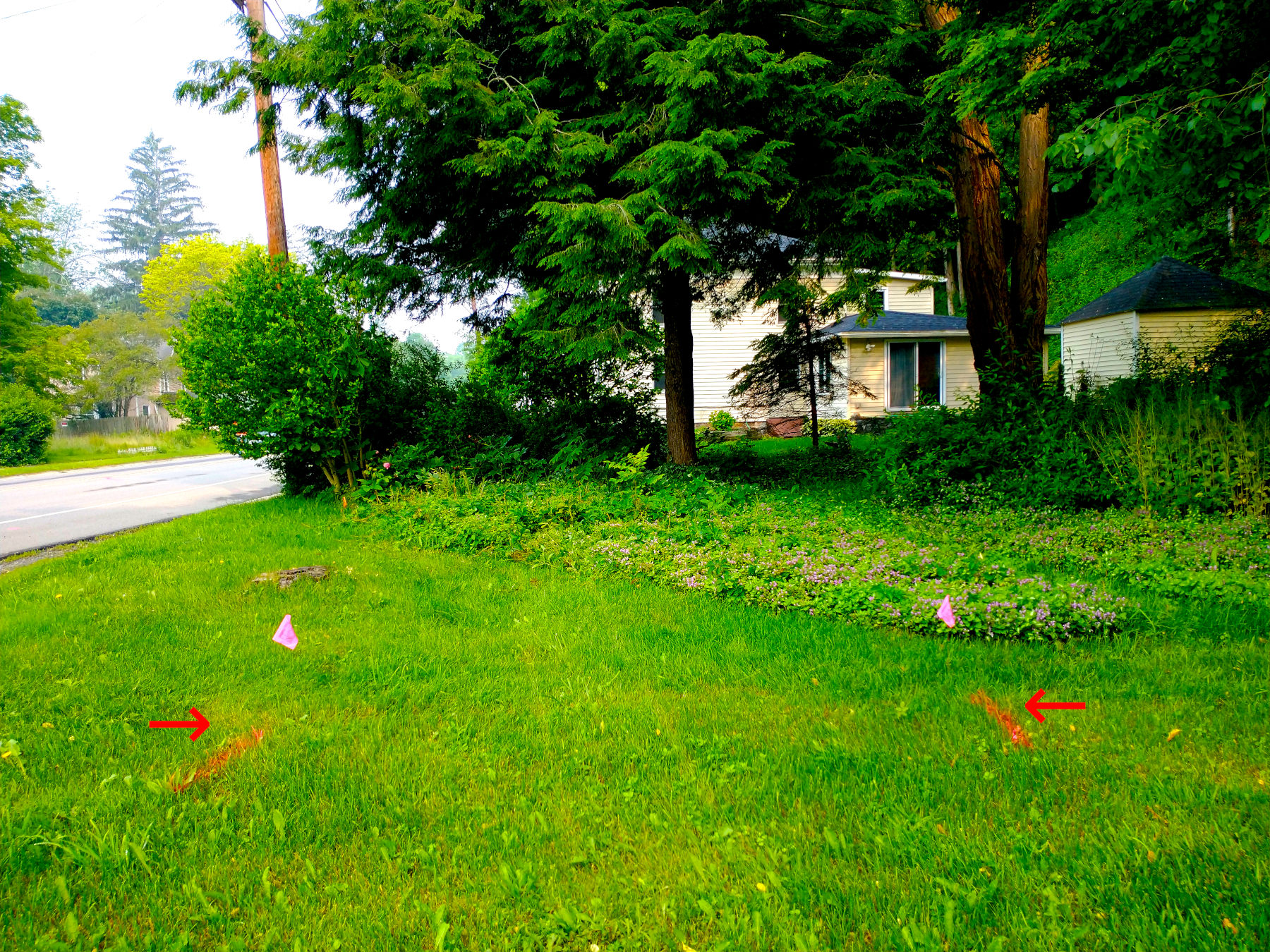
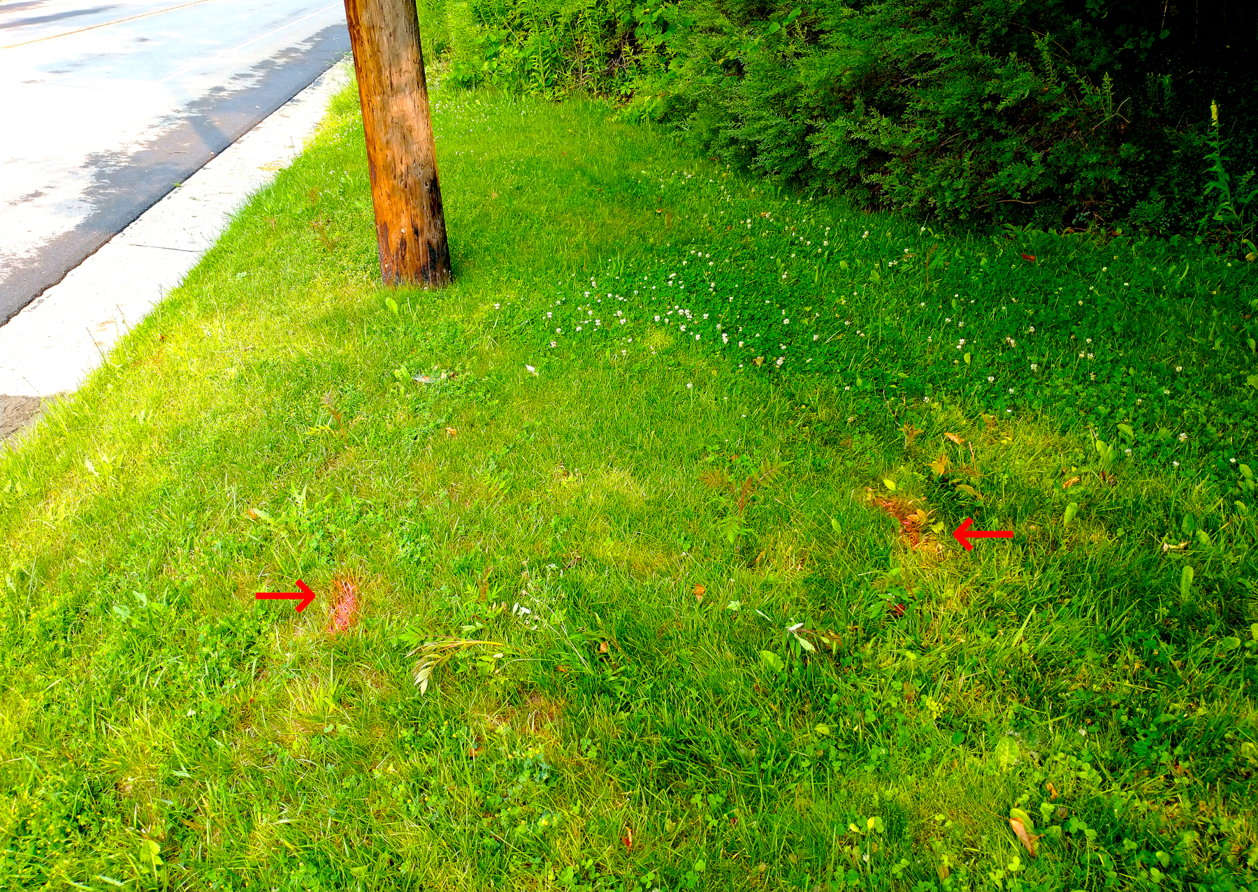
Evidence of the mill pond and the mill race can still be seen in the landscape as I write this. A clear example can be found in the disturbed area of fencing along the eastern side of Todi’s property in 2023, the property shown with the name Gardner Perry in the 1912 highway survey. In the following photographs, you can see the top of the fence dips in an area where wooden poles are reinforcing it.
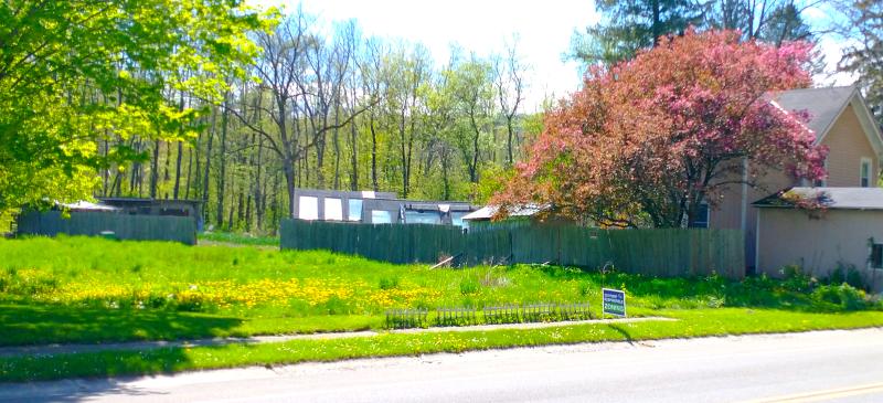
— 06 May 2023, Adam Smith. View largest available size.
— 06 May 2023, Adam Smith. View largest available size.

— 06 May 2023, Adam Smith. View largest available size.
The following survey from 1951 depicts the final feet of the “former mill tailrace” after crossing Todi’s and before rejoining Six Mile Creek.
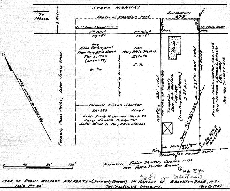
— 03 Mar 1951, Map of Public Welfare Property, Instrument Number BF000660-001, Tompkins County Clerk, Ithaca NY. View largest available size.
I really don't know anything about the building of 475, unfortunately.
Early on after moving there, I did have the unique and wonderful opportunity to meet an elderly man - Carl English who stopped by to chat while I was gardening.
I don't remember all of the info he shared....his family owned a dairy farm operation which included land that went from their home (large brick house at the corner of Quarry and Snyder Hill Rds) all the way down into Brooktondale.
As a young boy, he and his brother had been part of a work crew hired to fill in the creek / stream that ran from the mill pond (between you and the Dalebrook)...across B'dale Rd...through what's now an empty field between the Andersson's and the Todi's property....into Six Mile Creek. There was a bridge near 475 giving it the nickname "bridge's house" or something like that. This fill-in, while successful, resulted in fairly unstable land.
As I write this, based on Andrea Talmadge’s recollections of her conversation with Carl English, the mill raceway still exists, hidden underground, filled with stone instead of water. The remaining physical evidence, which would include soil disturbances from the creation of the channel and placement of bridge infrastructure, such as abutments, suggested to me the possibility that the location of the mill race bridge, and indeed, the entire length of the mill raceway could potentially be re-charted if this evidence could be uncovered.
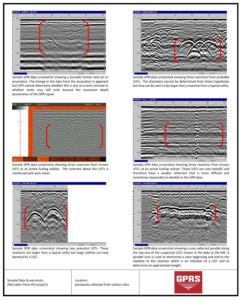
Obviously, the methods used must be non-invasive and non-destructive. I was vaguely aware of ground penetrating radar (GPR) and found a local company willing to try to locate the raceway based on my research at the time.
Ground-penetrating radar (GPR) is a geophysical method that uses radar pulses to image the subsurface. It is a non-intrusive method of surveying the sub-surface to investigate underground utilities such as concrete, asphalt, metals, pipes, cables or masonry. This nondestructive method uses electromagnetic radiation in the microwave band (UHF/VHF frequencies) of the radio spectrum, and detects the reflected signals from subsurface structures. GPR can have applications in a variety of media, including rock, soil, ice, fresh water, pavements and structures. In the right conditions, practitioners can use GPR to detect subsurface objects, changes in material properties, and voids and cracks.
GPR uses high-frequency (usually polarized) radio waves, usually in the range 10 MHz to 2.6 GHz. A GPR transmitter and antenna emits electromagnetic energy into the ground. When the energy encounters a buried object or a boundary between materials having different permittivities, it may be reflected or refracted or scattered back to the surface. A receiving antenna can then record the variations in the return signal. The principles involved are similar to seismology, except GPR methods implement electromagnetic energy rather than acoustic energy, and energy may be reflected at boundaries where subsurface electrical properties change rather than subsurface mechanical properties as is the case with seismic energy.
— Ground-penetrating radar, Wikipedia.org.
My goal was to try to unequivocally find the mill raceway and verify the approximate location of the bridge for comparison against the survey maps, and also to record any findings in such a way that others, particularly future 475ers, could find the same points with reasonable accuracy in the future with less effort than it took me.
On 29 Jun 2023, witnessed by me, a technician from the company Ground Penetrating Radar Systems scanned the western part of the Dalebrook lot, the Mills’ Home lot, and the road in front of Mills Home on both the northern and southern sides. I also had him look for evidence of the barn, that will be presented in that section.
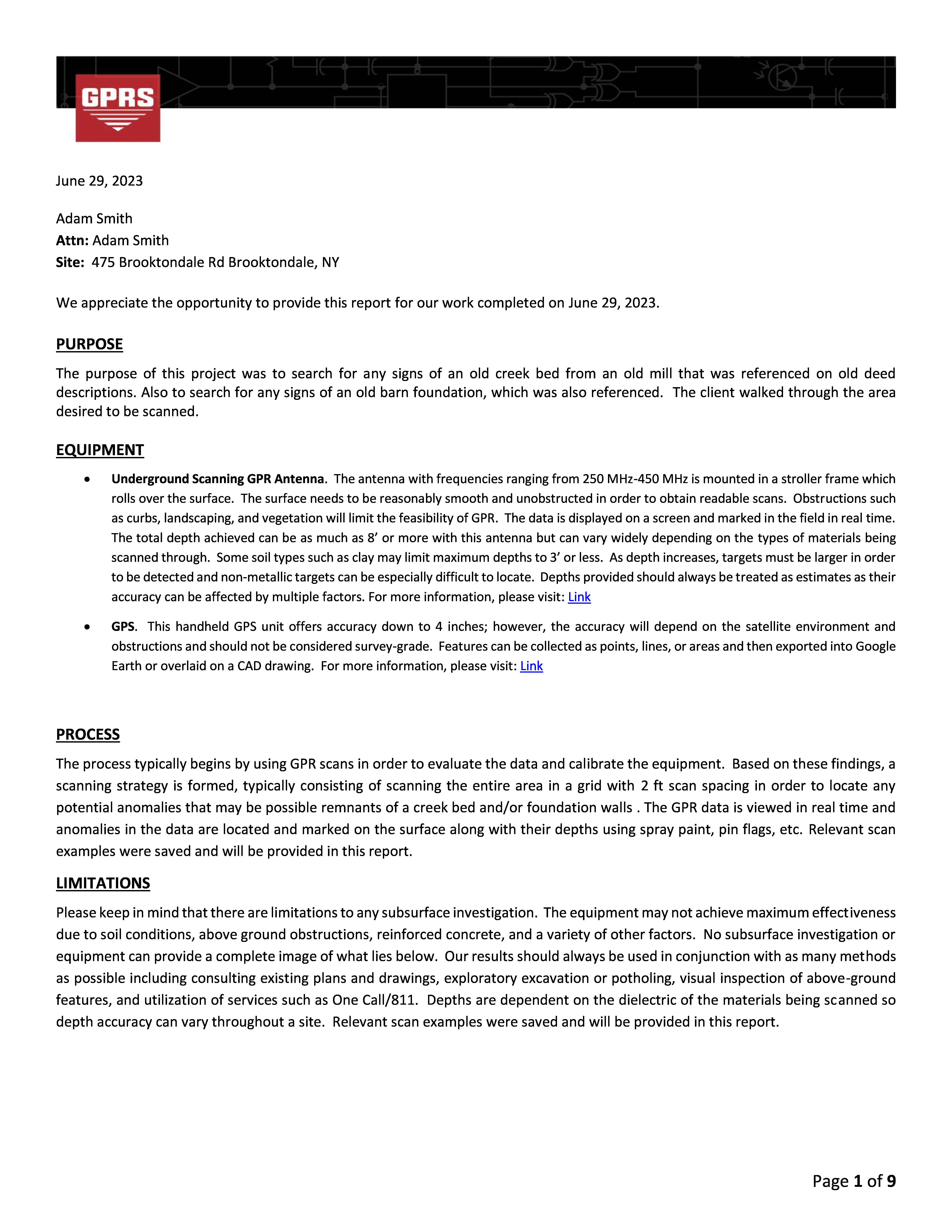
Mike Bishop, the GPR technician, used the word “confident” to describe the GPR findings and the marks he was making, although obviously there is going to be some level of imprecision in where he placed the marks based on his interpretation of the scans. Also note that page 2 of the GPR report below states “GPR imagery was very poor on the asphalt”, and in a 06 Jul 2023 follow-up email, he said “the [GPS] signal wasn’t the greatest”. Otherwise, the following pages from the GPR report describe the process, limitations, and findings.

June 29, 2023
Adam Smith Attn: Adam Smith Site: 475 Brooktondale Rd Brooktondale, NY
We appreciate the opportunity to provide this report for our work completed on June 29, 2023.
PURPOSE
The purpose of this project was to search for any signs of an old creek bed from an old mill that was referenced on old deed descriptions. Also to search for any signs of an old barn foundation, which was also referenced. The client walked through the area desired to be scanned.
EQUIPMENT
Underground Scanning GPR Antenna. The antenna with frequencies ranging from 250 MHz-450 MHz is mounted in a stroller frame which rolls over the surface. The surface needs to be reasonably smooth and unobstructed in order to obtain readable scans. Obstructions such as curbs, landscaping, and vegetation will limit the feasibility of GPR. The data is displayed on a screen and marked in the field in real time. The total depth achieved can be as much as 8’ or more with this antenna but can vary widely depending on the types of materials being scanned through. Some soil types such as clay may limit maximum depths to 3’ or less. As depth increases, targets must be larger in order to be detected and non-metallic targets can be especially difficult to locate. Depths provided should always be treated as estimates as their accuracy can be affected by multiple factors. For more information, please visit: Link
GPS. This handheld GPS unit offers accuracy down to 4 inches; however, the accuracy will depend on the satellite environment and obstructions and should not be considered survey-grade. Features can be collected as points, lines, or areas and then exported into Google Earth or overlaid on a CAD drawing. For more information, please visit: Link
PROCESS
The process typically begins by using GPR scans in order to evaluate the data and calibrate the equipment. Based on these findings, a scanning strategy is formed, typically consisting of scanning the entire area in a grid with 2 ft scan spacing in order to locate any potential anomalies that may be possible remnants of a creek bed and/or foundation walls . The GPR data is viewed in real time and anomalies in the data are located and marked on the surface along with their depths using spray paint, pin flags, etc. Relevant scan examples were saved and will be provided in this report.
LIMITATIONS
Please keep in mind that there are limitations to any subsurface investigation. The equipment may not achieve maximum effectiveness due to soil conditions, above ground obstructions, reinforced concrete, and a variety of other factors. No subsurface investigation or equipment can provide a complete image of what lies below. Our results should always be used in conjunction with as many methods as possible including consulting existing plans and drawings, exploratory excavation or potholing, visual inspection of above-ground features, and utilization of services such as One Call/811. Depths are dependent on the dielectric of the materials being scanned so depth accuracy can vary throughout a site. Relevant scan examples were saved and will be provided in this report.
Page 1 of 9
— 29 Jun 2023, Ground Penetrating Radar Systems Report for 475 Brooktondale Road, p1. View largest available size.

FINDINGS
The subsurface conditions at the time of the scanning allowed for maximum GPR depth penetration of 2-3 ft in most areas. GPR imagery was very poor on the asphalt. The following pages will provide further explanation of the findings. The equipment and methods used did not detect reactions from potential barn foundations, but did detect reactions of the suspected creek bed. The following pages will provide further explanation of the findings.
Page 2 of 9
— 29 Jun 2023, Ground Penetrating Radar Systems Report for 475 Brooktondale Road, p2. View largest available size.
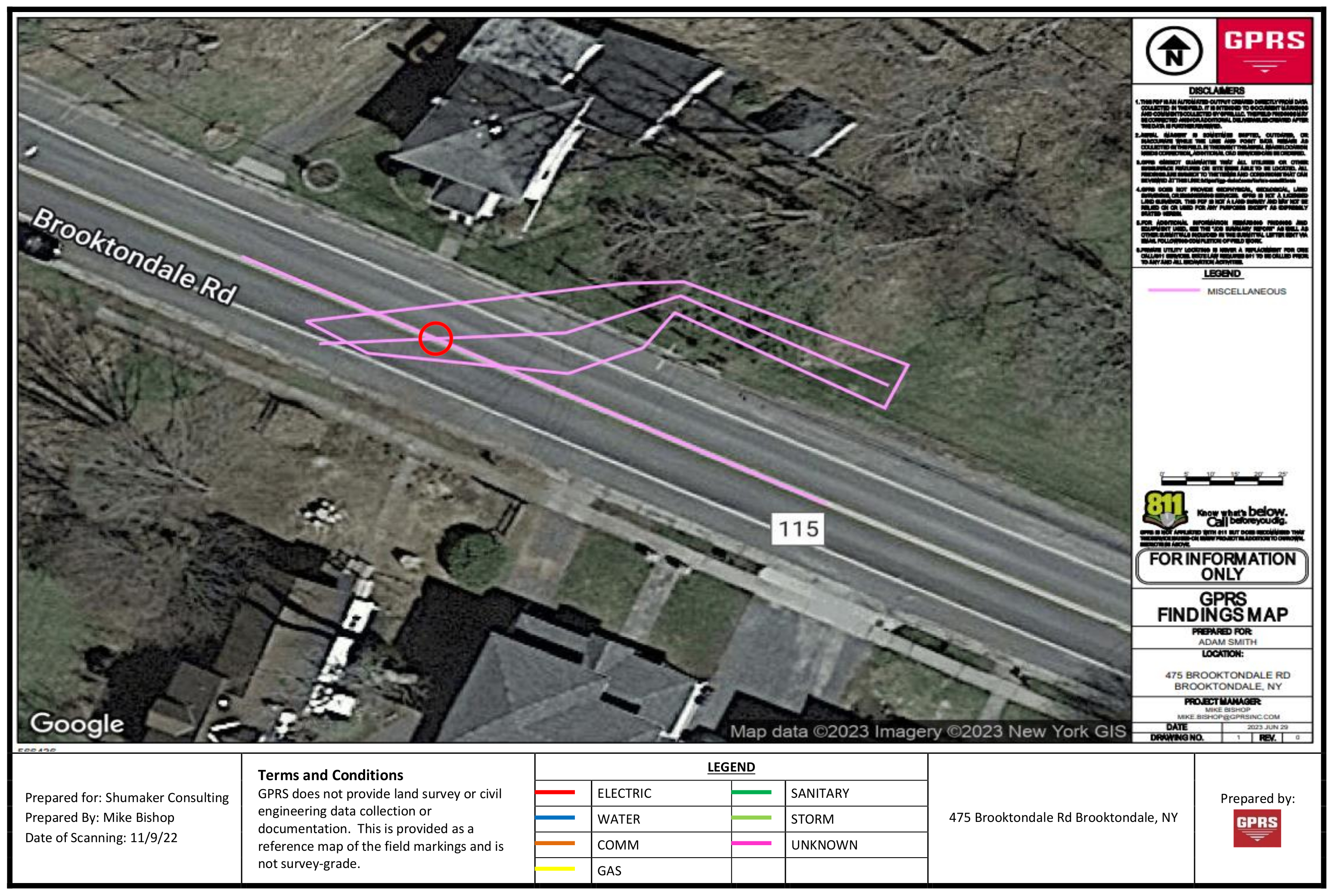
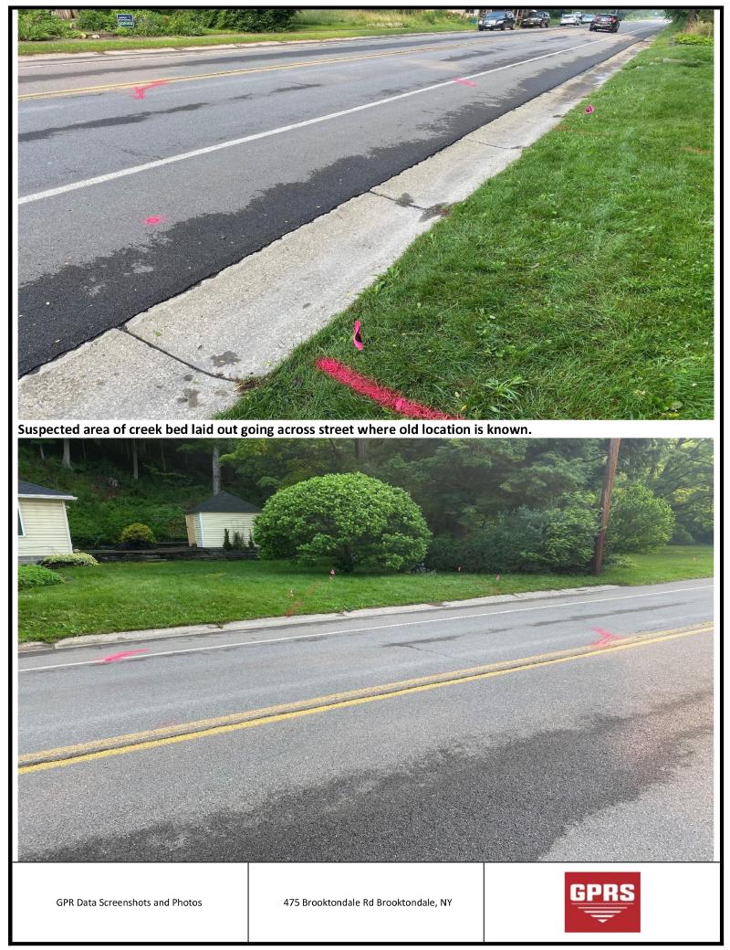
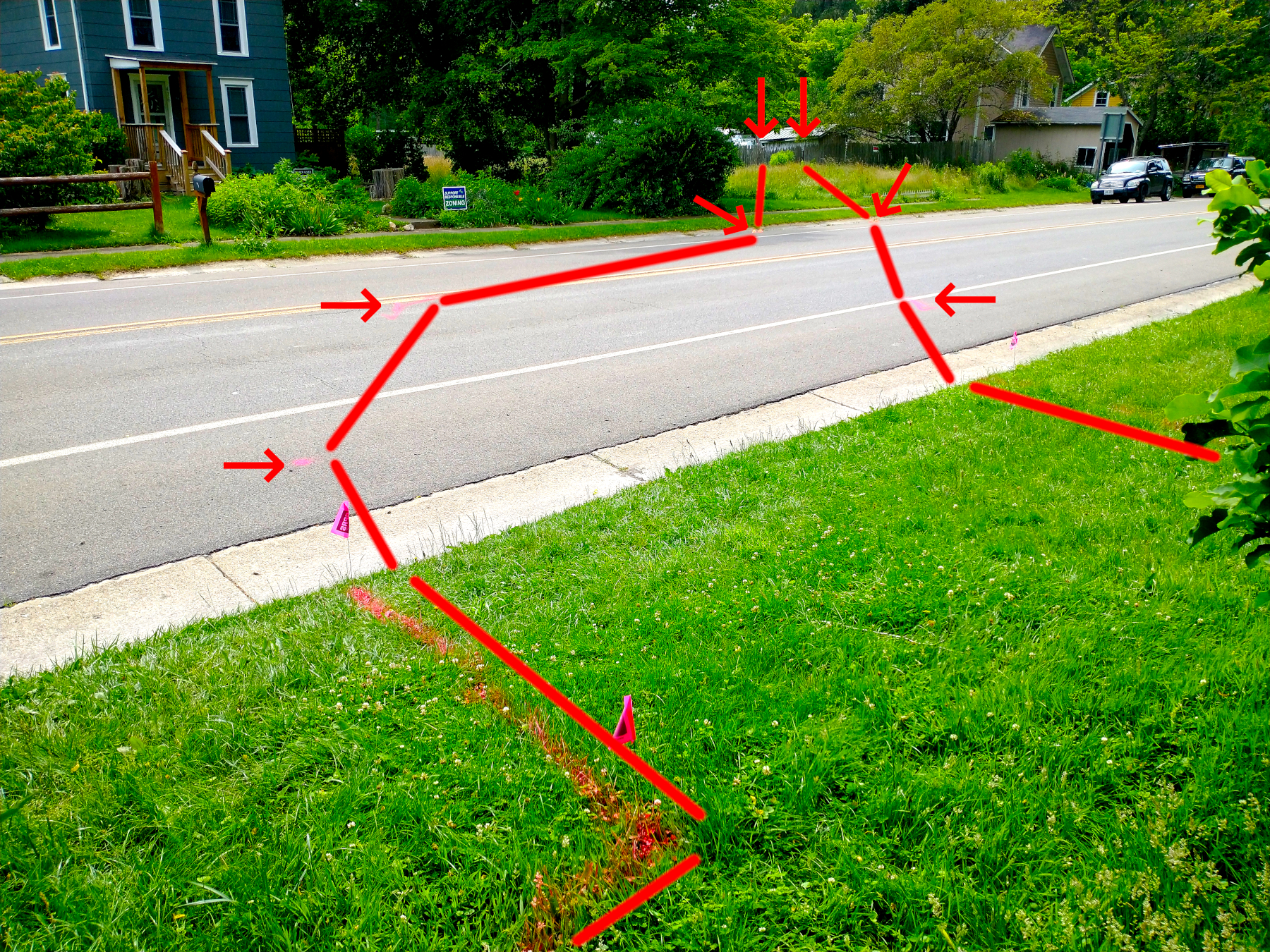
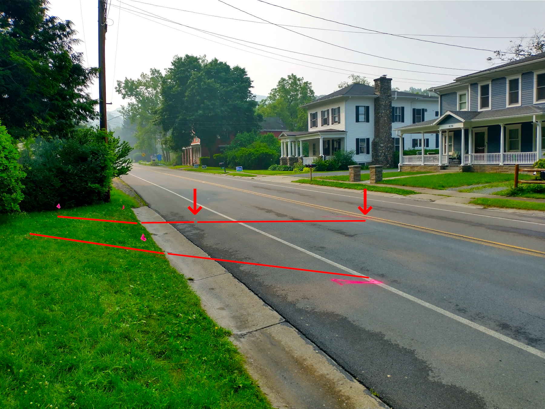
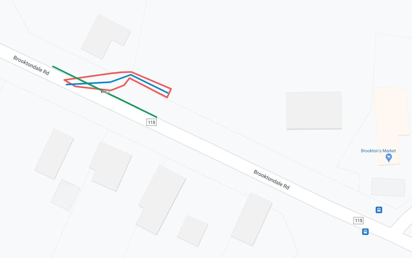
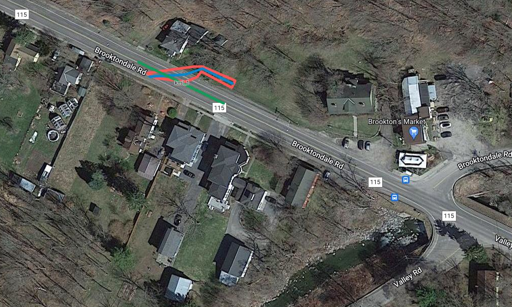
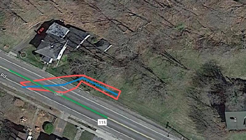
Along with the caveat about the strength of the Global Positioning System (GPS) signal, I would also add that in the following projection onto Google Maps, the images of the structures on the property appear to be distorted, and in my opinion, they don’t give the best sense of where the raceway falls relative to the structures, compared to how they seem to me to fall when I am actually outside looking at the markings made. I also asked Mike to take GPS readings down the center of the road and the center of the detected channel, and I have circled in red the center of the detected channel at the center of the present road.

— 29 Jun 2023, Ground Penetrating Radar Systems Report for 475 Brooktondale Road, p3. View largest available size.
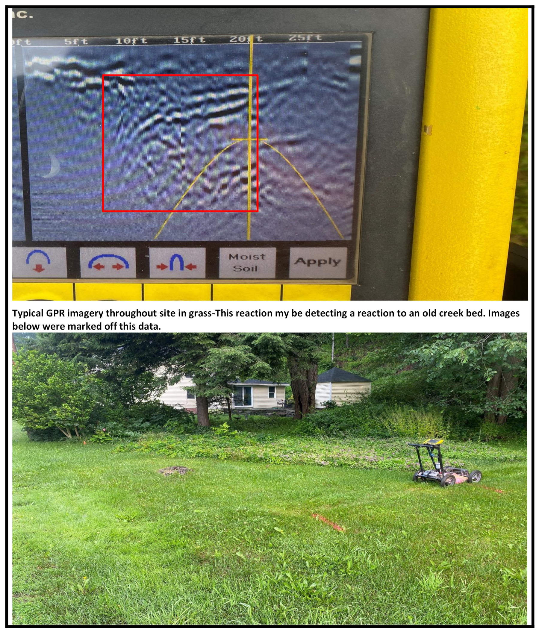
More images from the report show the GPR readings with photographs of where they were captured as well as guidance for interpreting the scans.
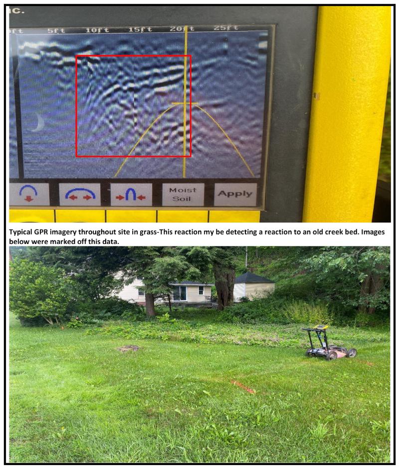
— 29 Jun 2023, Ground Penetrating Radar Systems Report for 475 Brooktondale Road, p5. View largest available size.
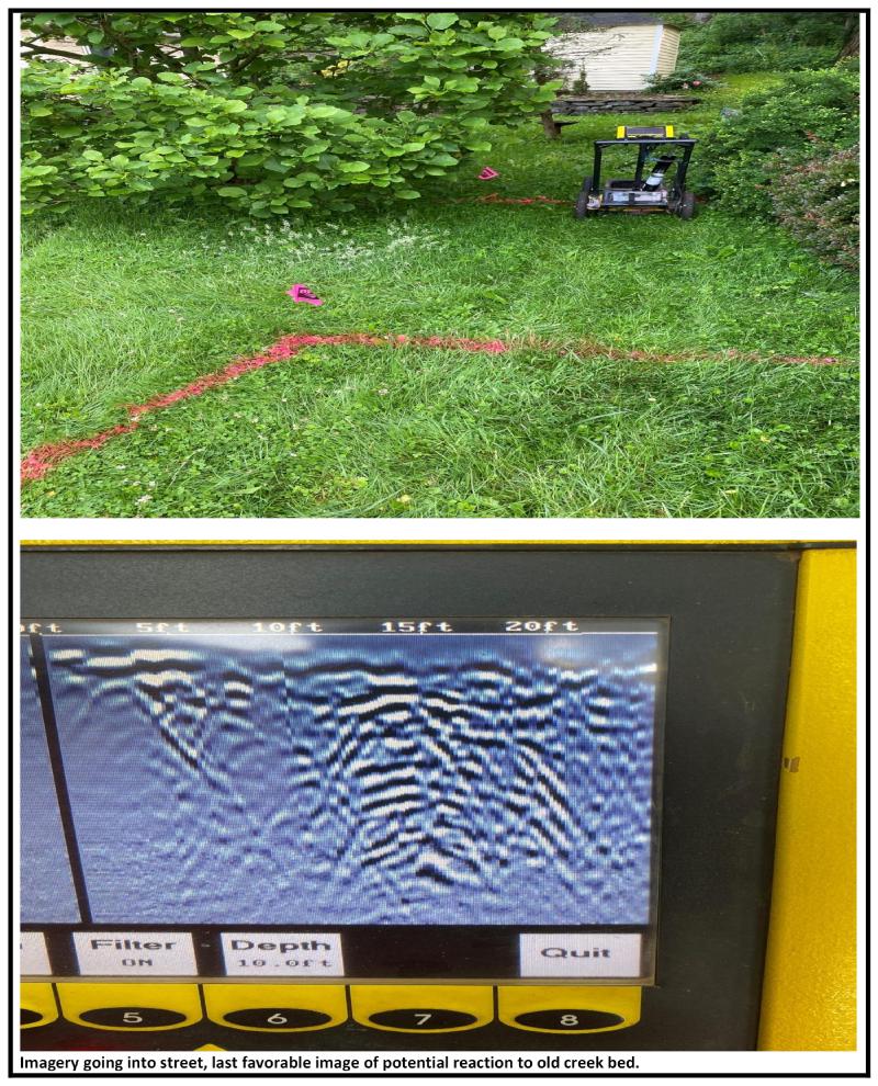
— 29 Jun 2023, Ground Penetrating Radar Systems Report for 475 Brooktondale Road, p7. View largest available size.
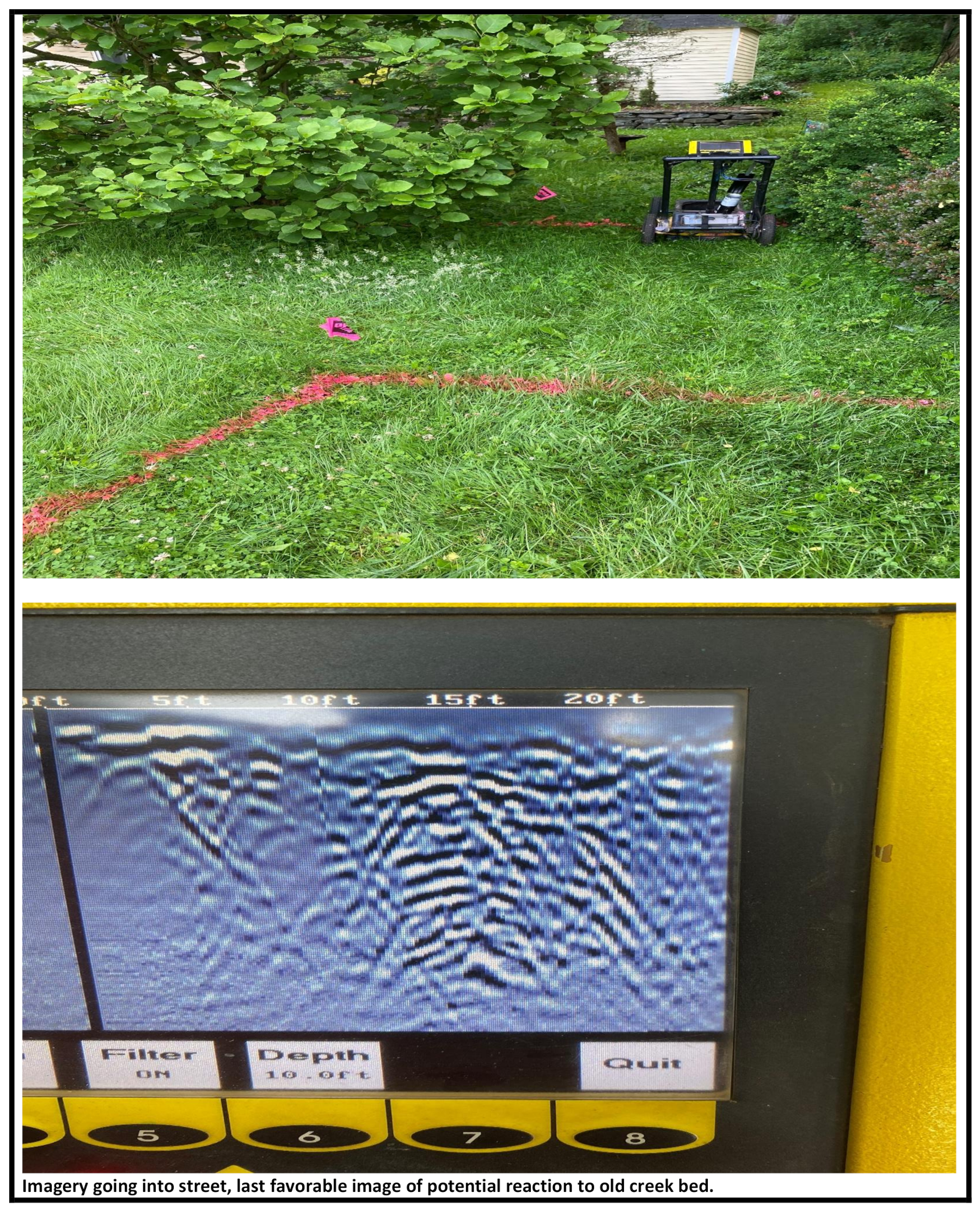
— 29 Jun 2023, Ground Penetrating Radar Systems Report for 475 Brooktondale Road, p7. View largest available size.
— 29 Jun 2023, Ground Penetrating Radar Systems Report for 475 Brooktondale Road, p4. View largest available size.
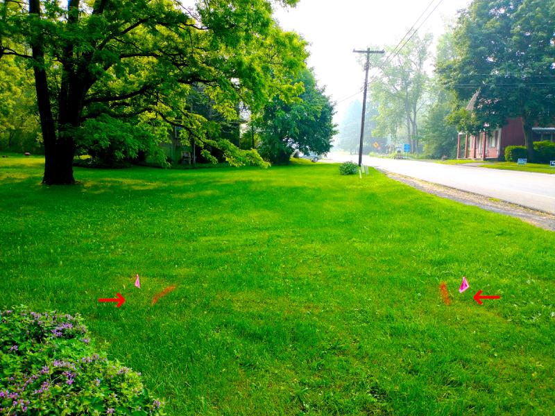
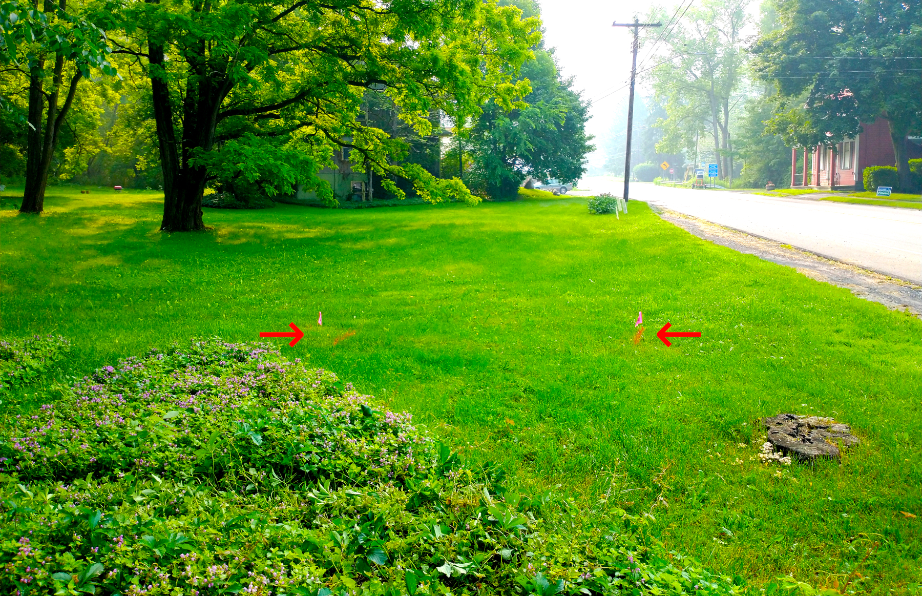
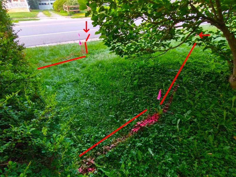
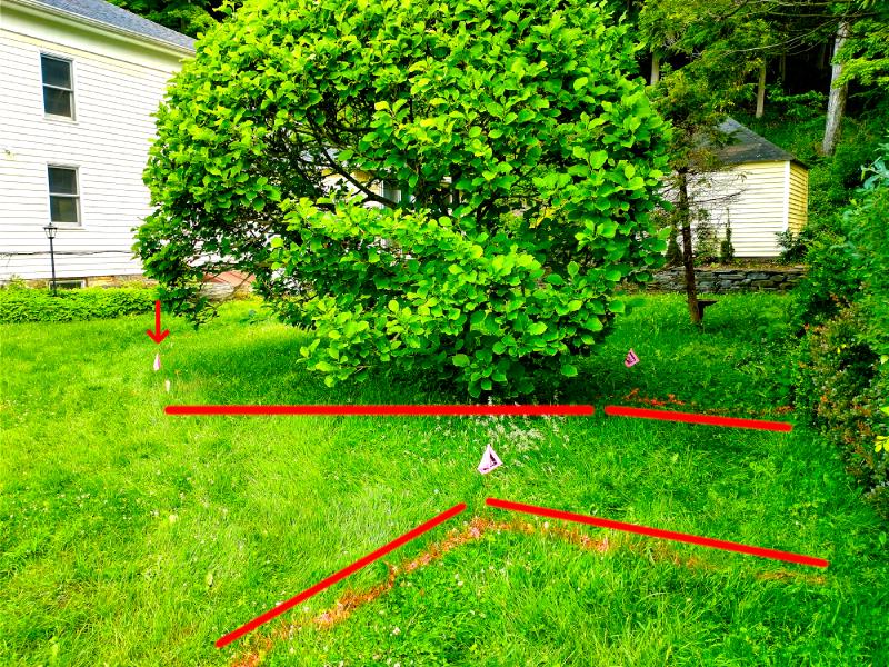
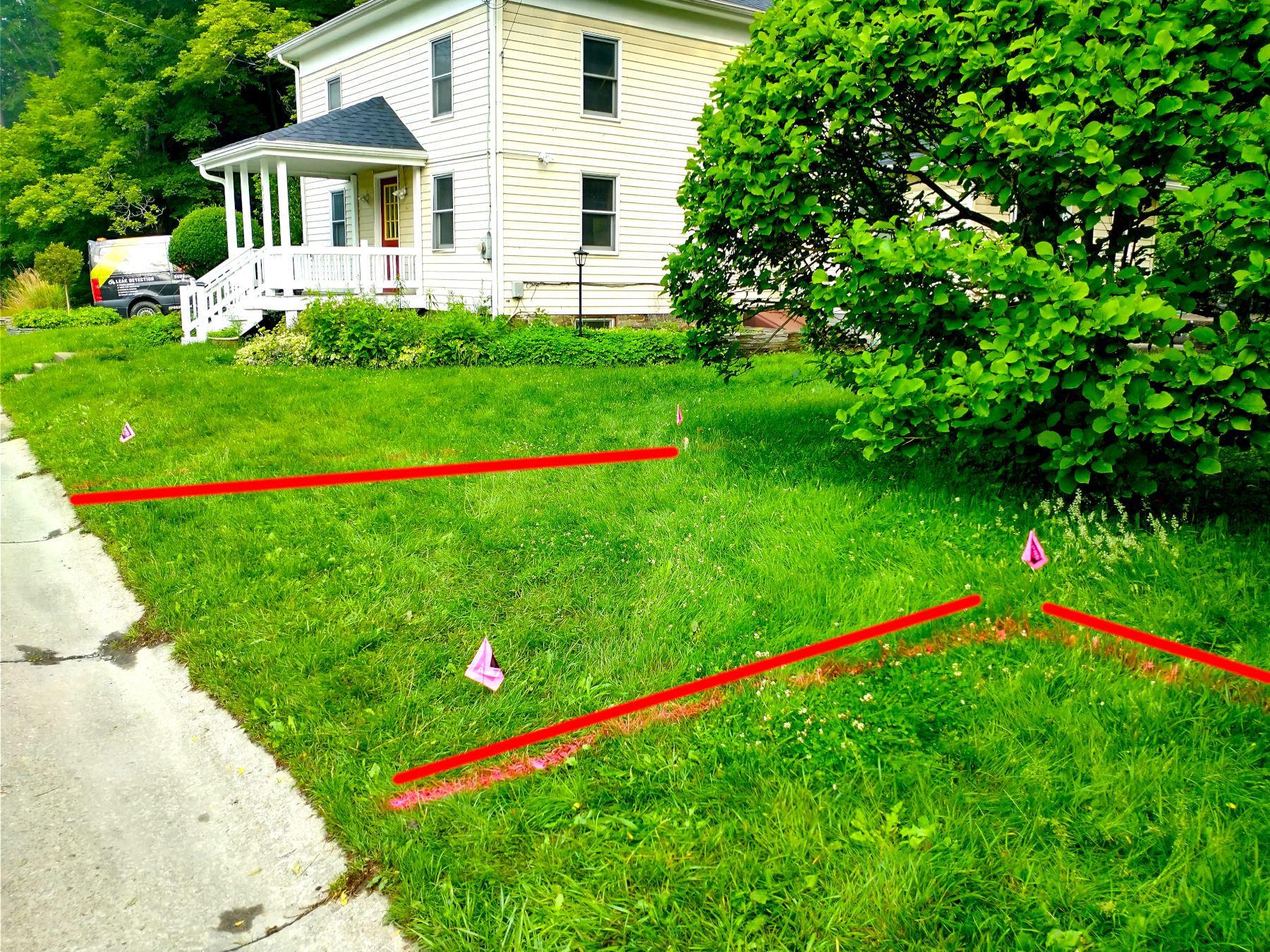
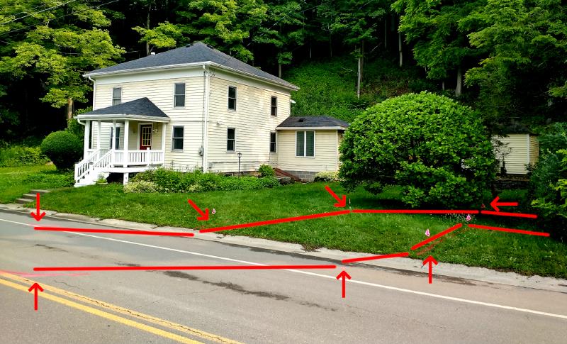
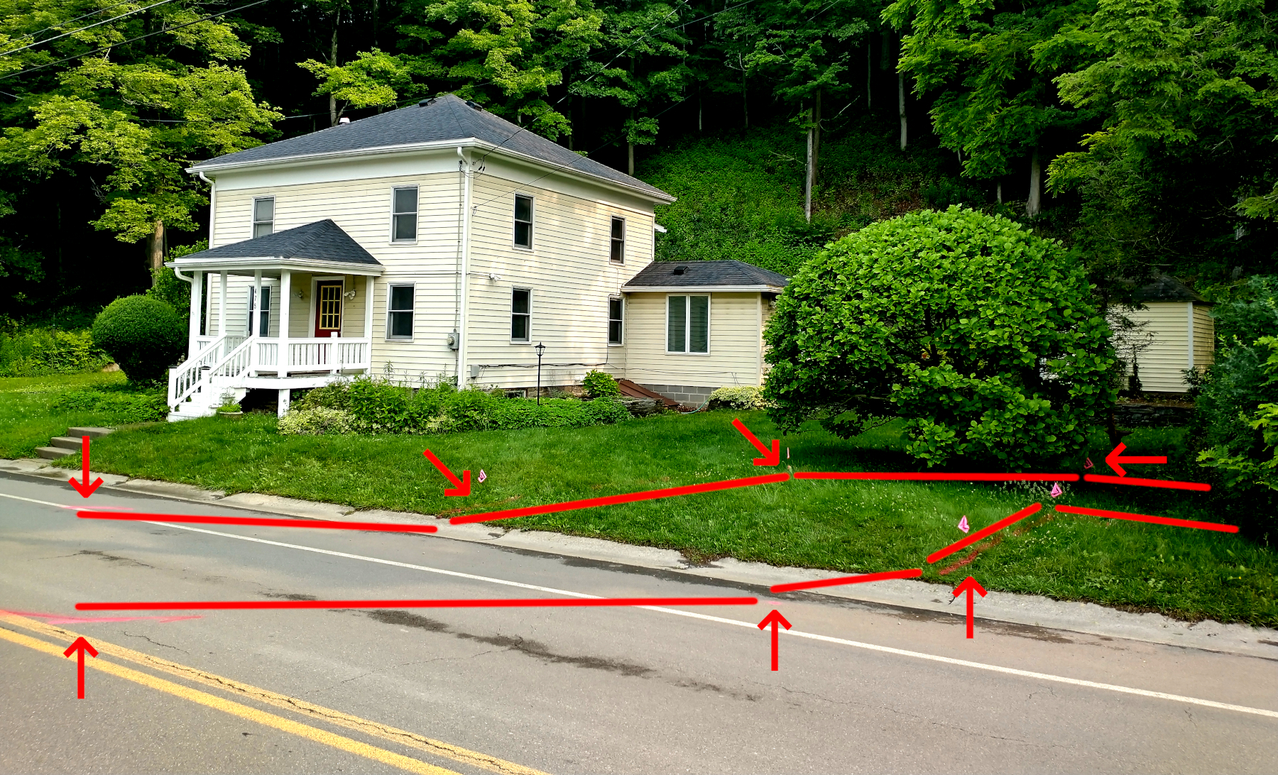
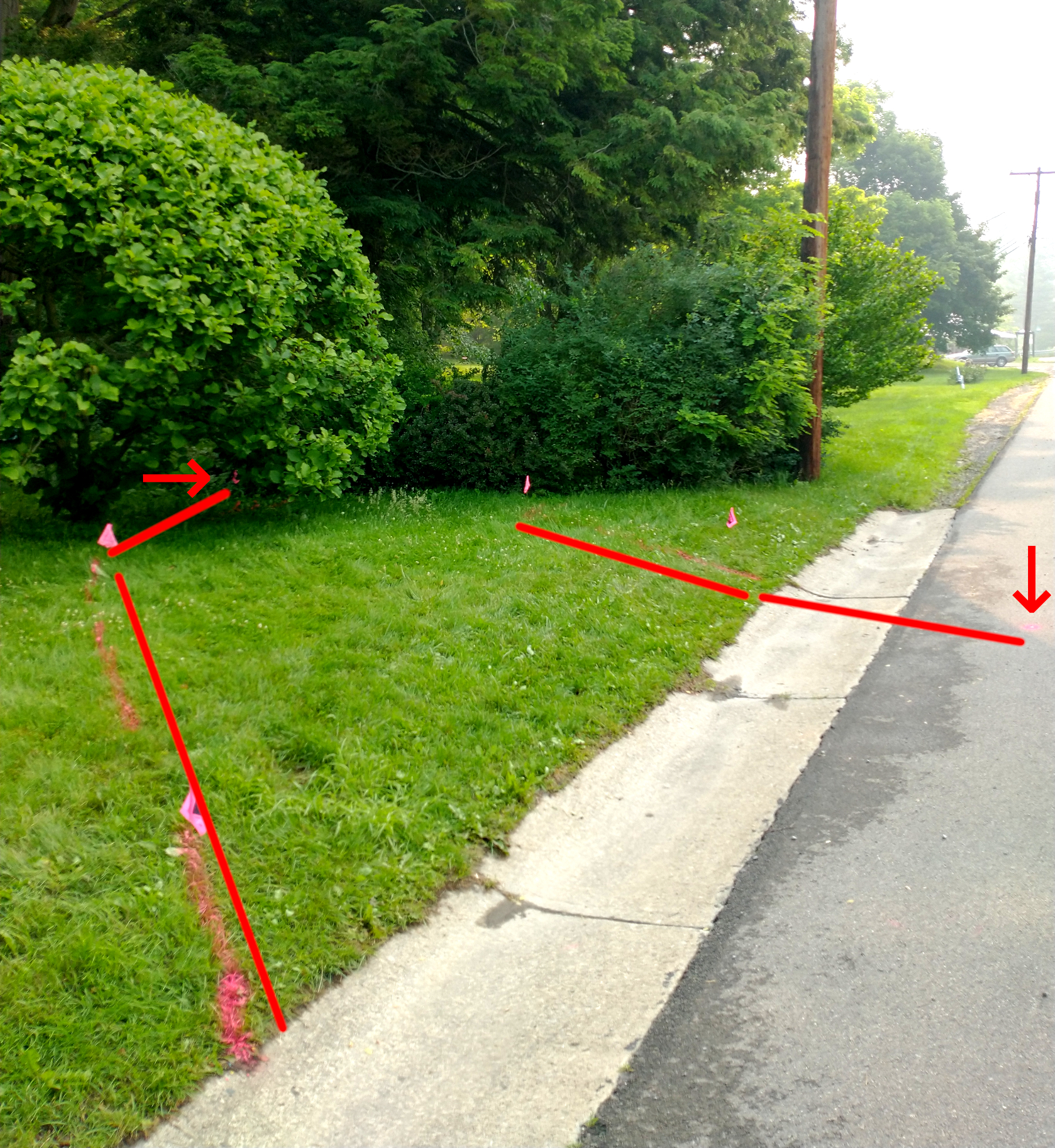
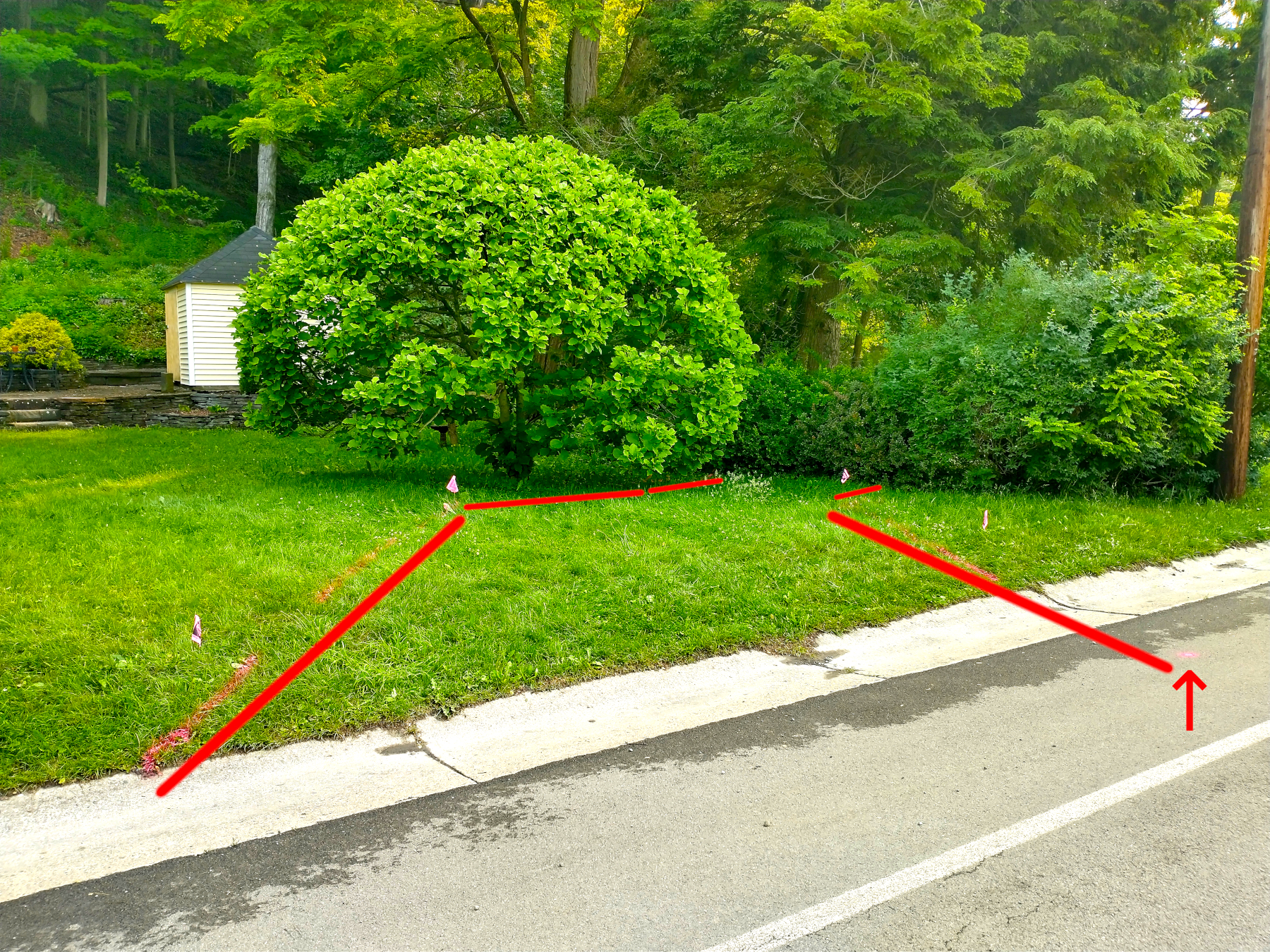
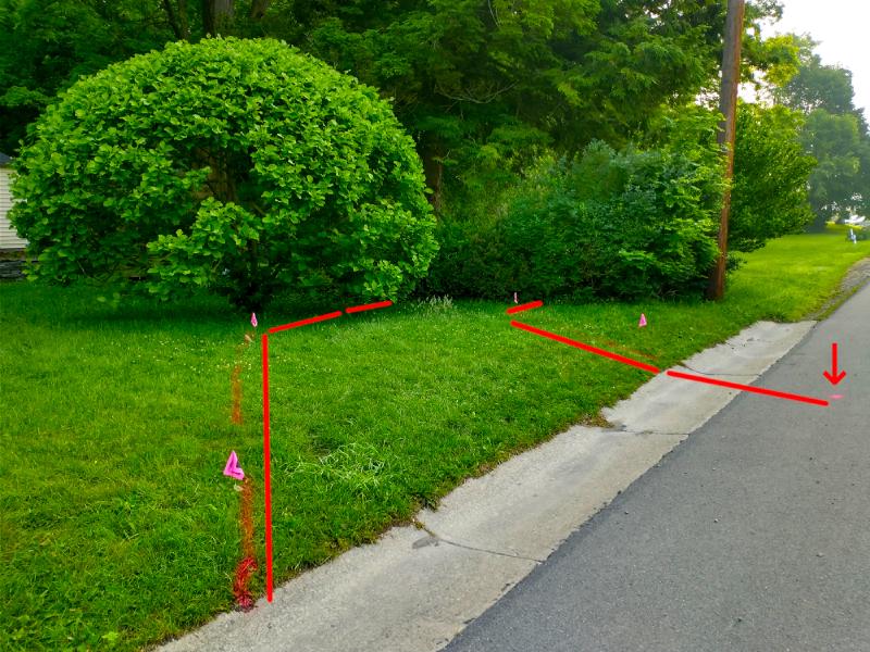
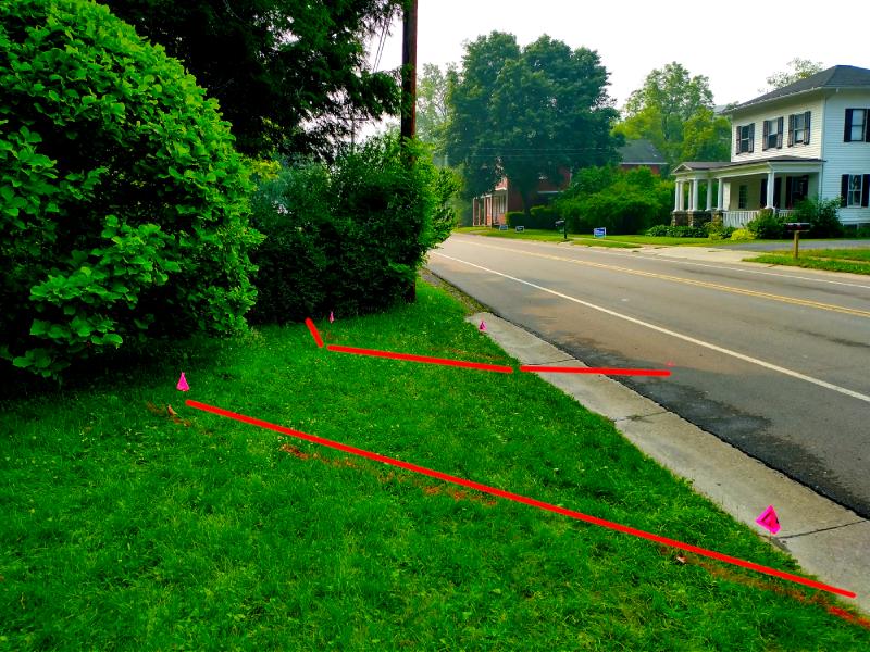
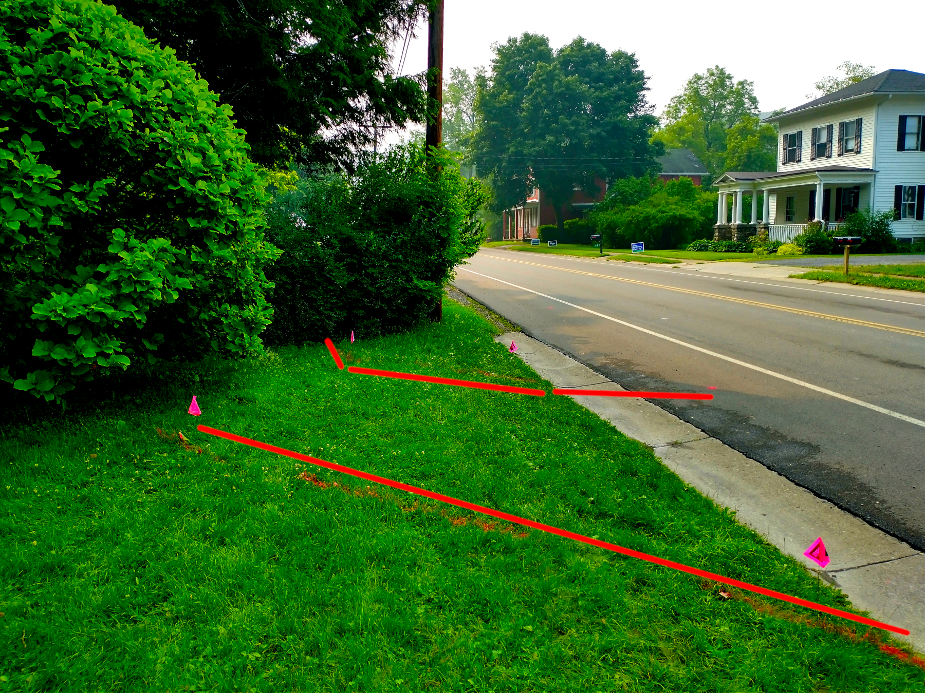
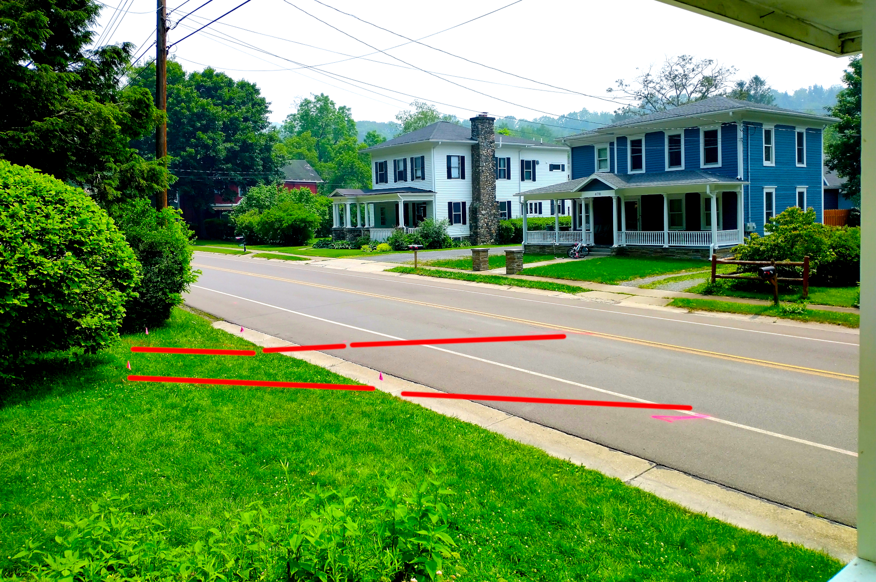
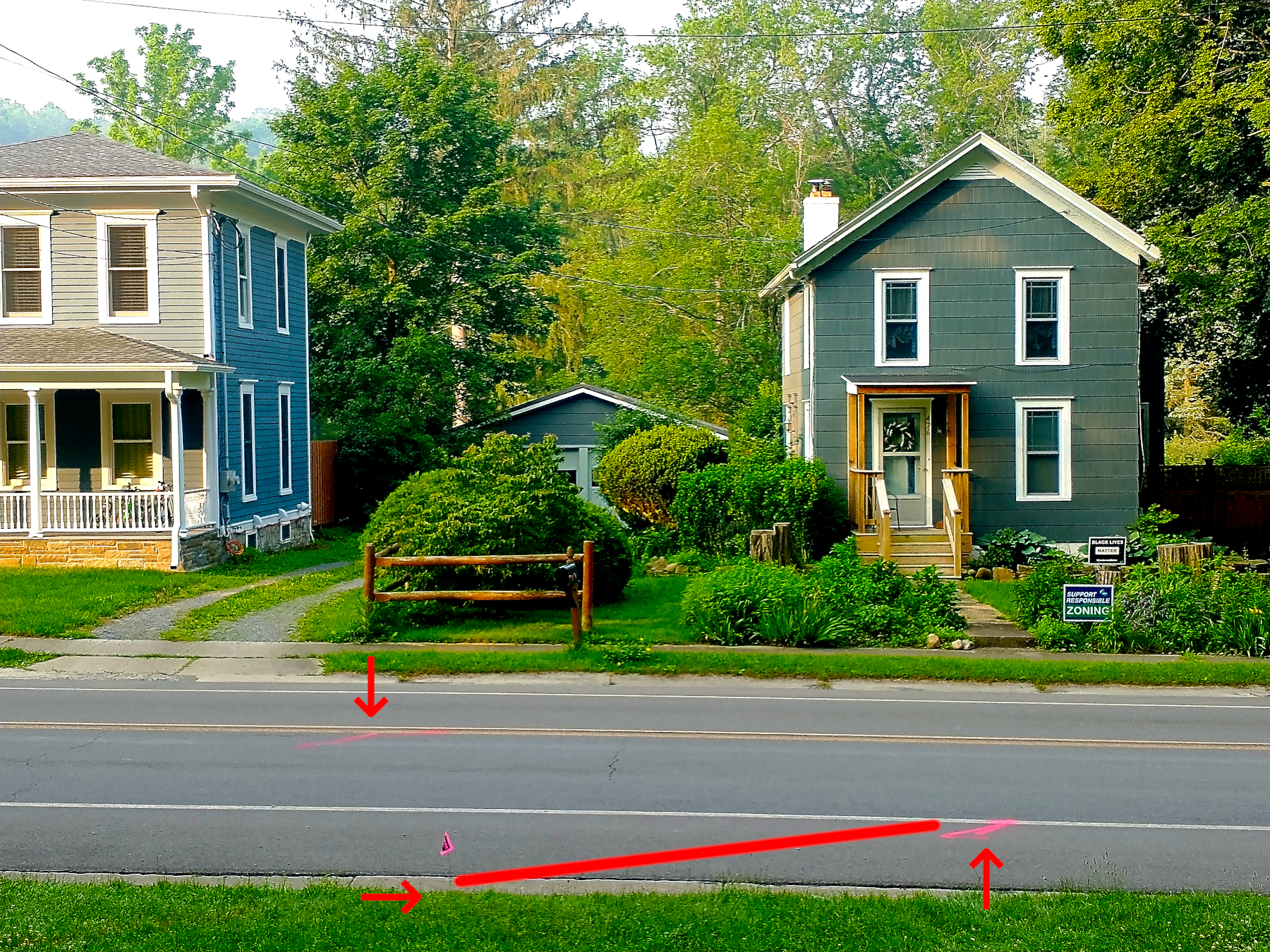
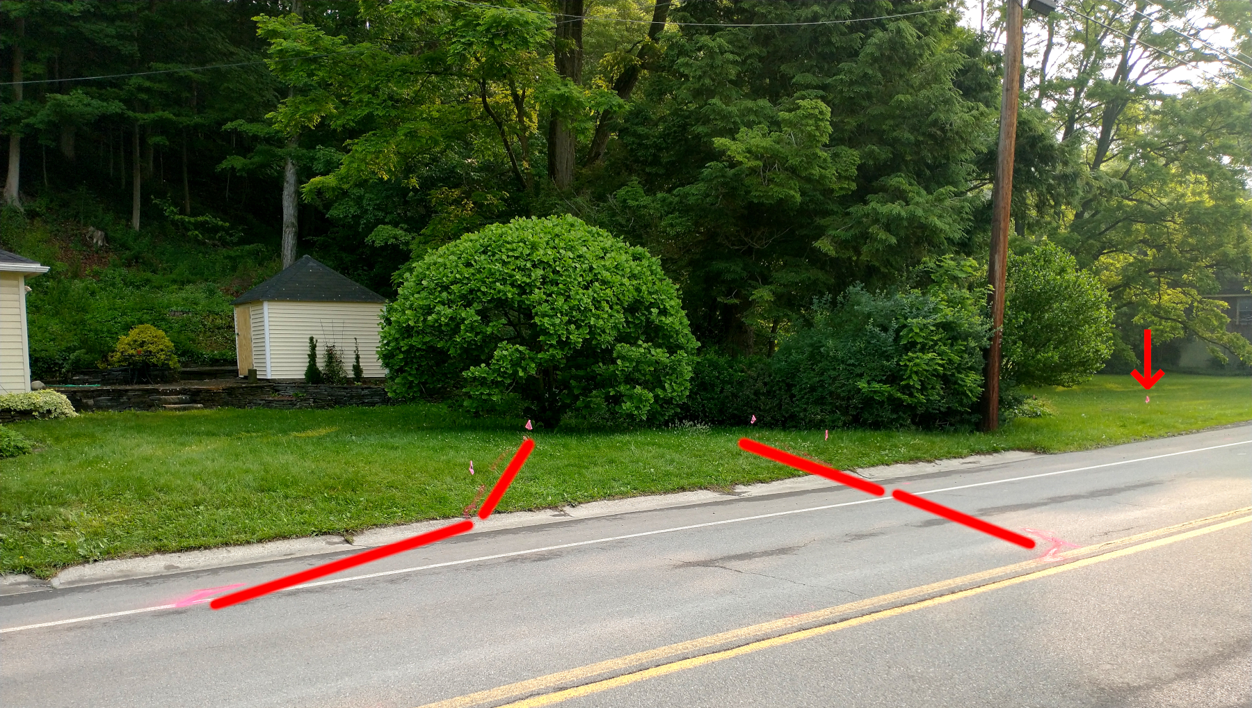
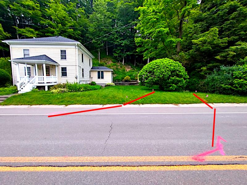
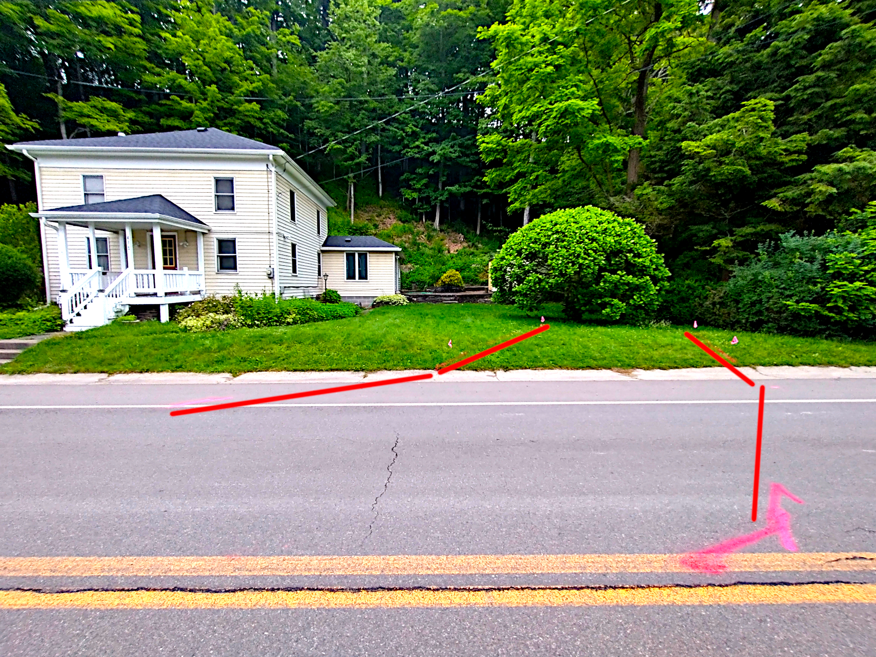
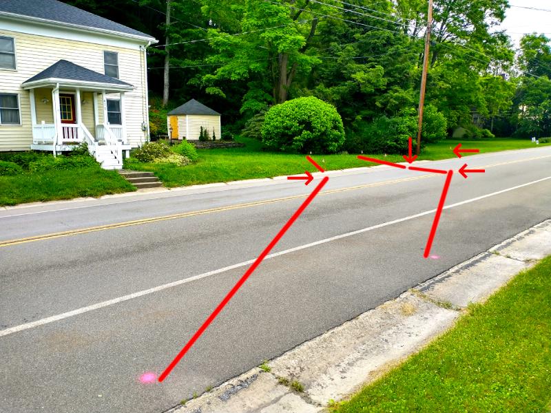
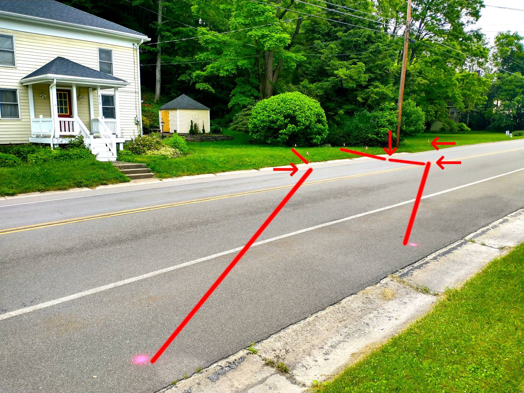
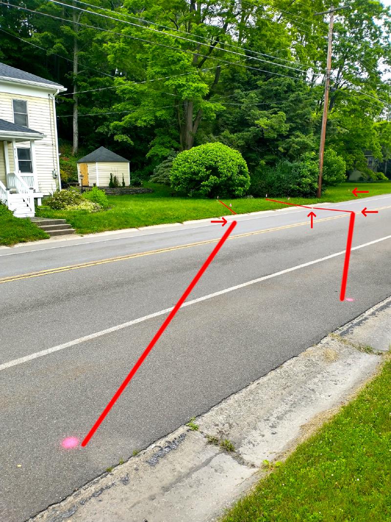
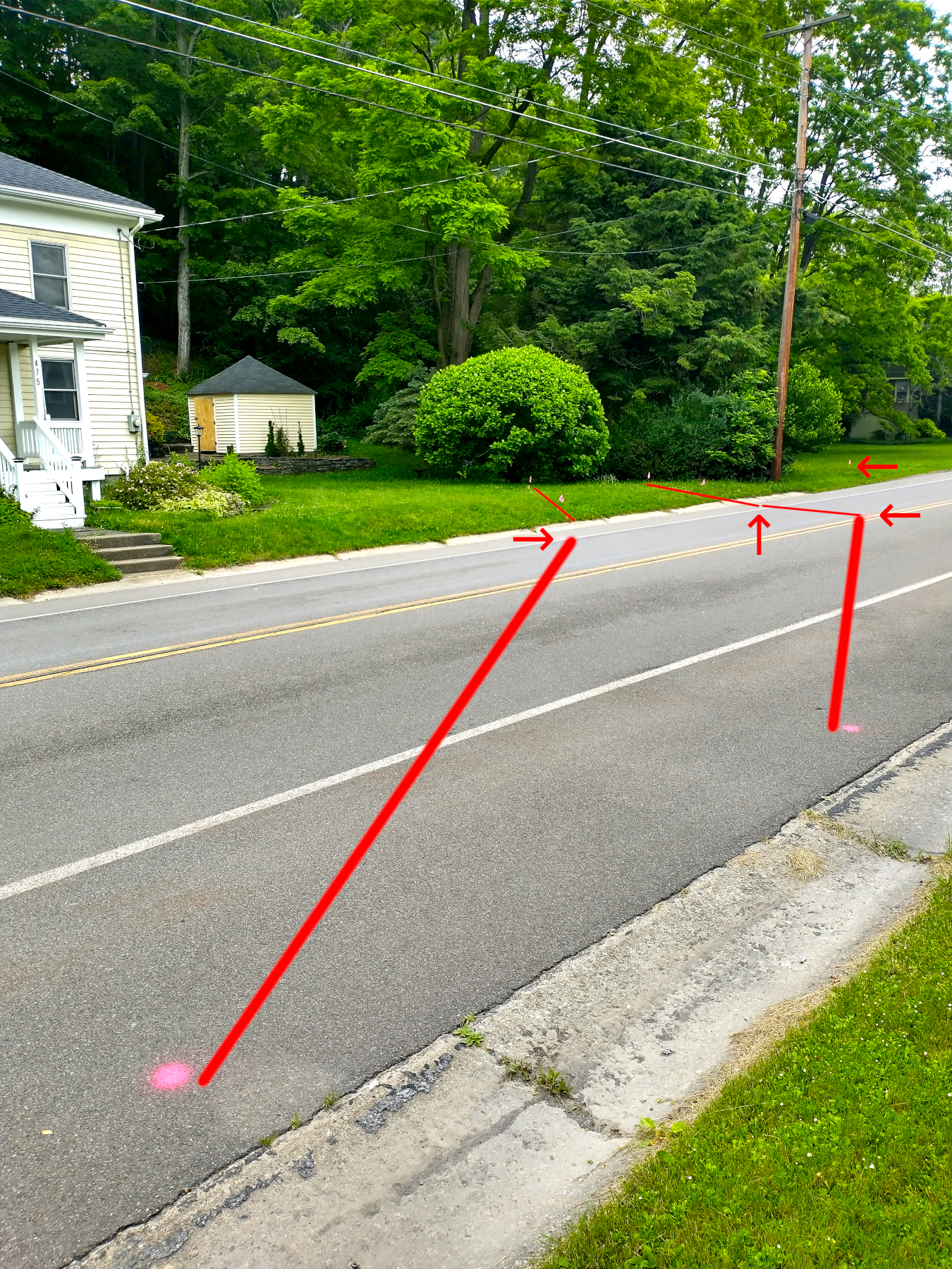
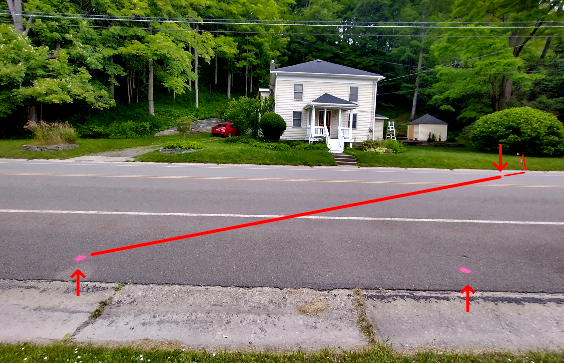
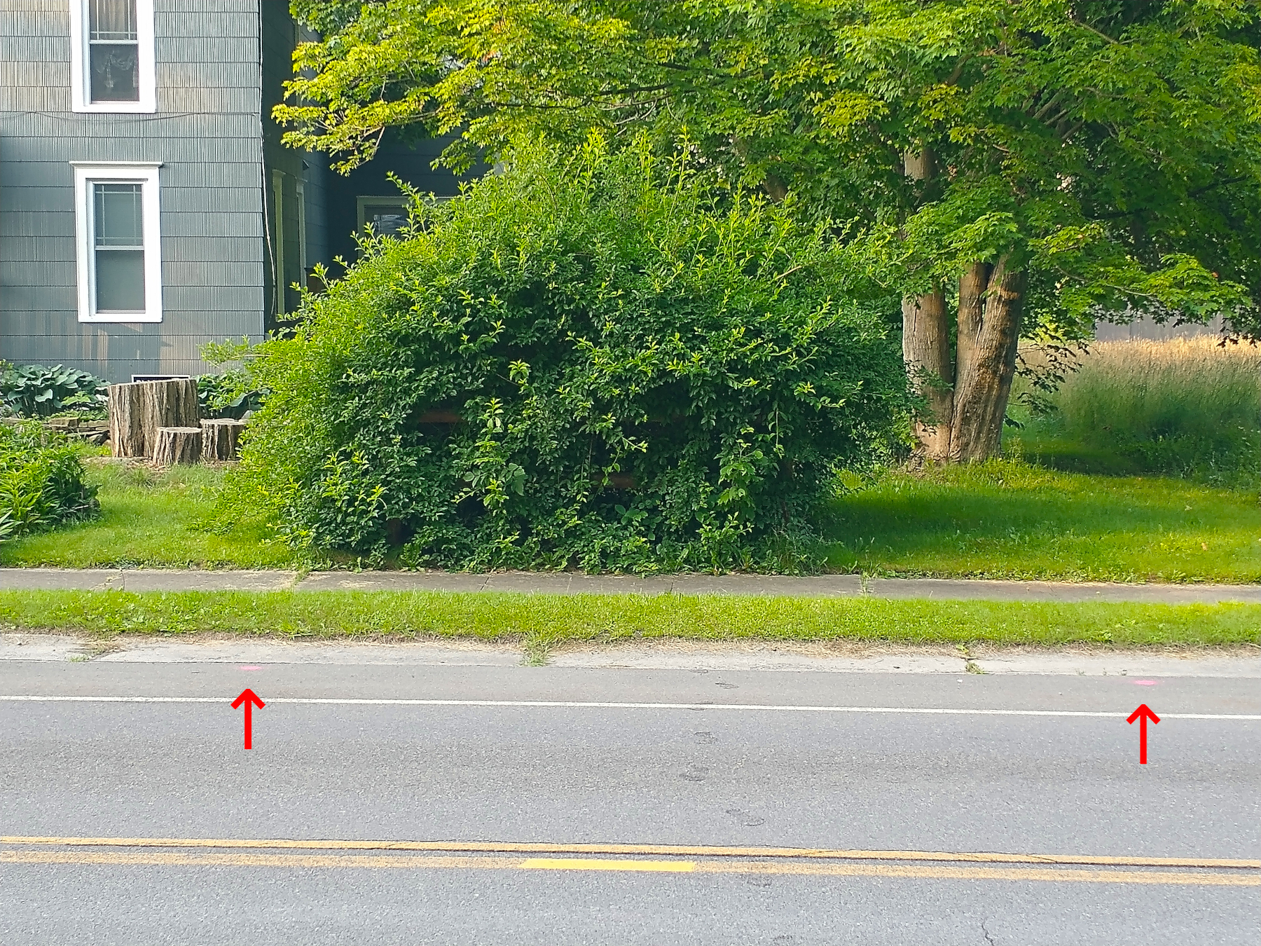
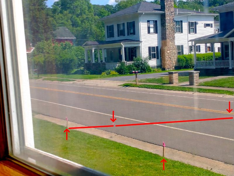
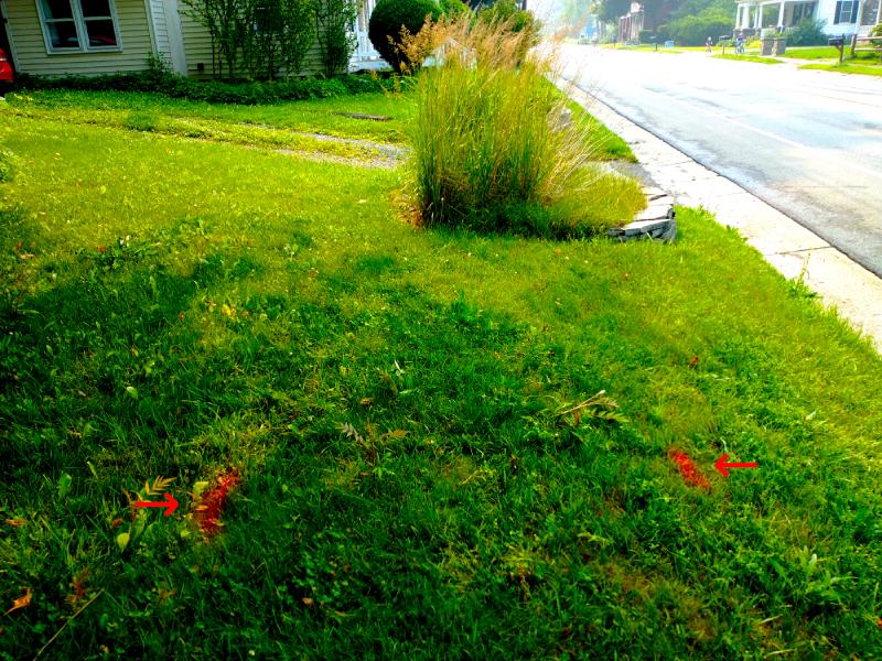
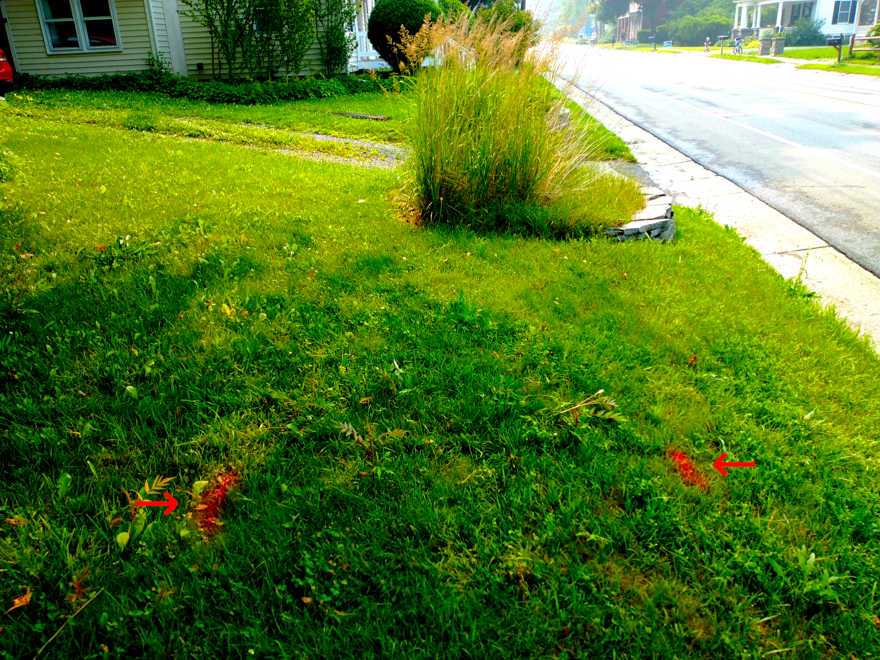
Further below, I will compare these findings against the Mills’ Home survey maps. For now, I have supplemented the GPR report with my own photographs that include red lines and arrows to further highlight the red spray paint and pink pin flags, to try to give a better sense of the raceway.
Beginning on the Dalebrook lot, the raceway approaches and crosses the boundary with Mills’ Home on a course parallel to Brooktondale Road.

— 29 Jun 2023, Adam Smith. View largest available size.
— 29 Jun 2023, Adam Smith. View largest available size.

— 29 Jun 2023, Adam Smith. View largest available size.
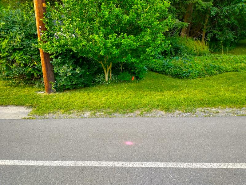
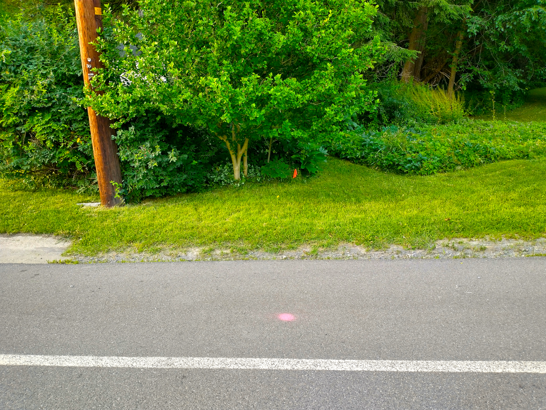
I want to briefly note that an isolated marking was also made that falls approximately on a line perpendicular to the road from Miller’s Bent Pipe set in 1972, indicated with an orange pin flag set by Dresser in March 2023.
— 06 Jul 2023, Adam Smith. View largest available size.
(Note that the spray paint appears darker red on the grass, and pink on the asphalt road.)
After crossing the shared boundary line, the raceway turns toward the road close to the small magnolia tree:
— 30 Jun 2023, Adam Smith. View largest available size.
— 29 Jun 2023, Adam Smith. View largest available size.

— 29 Jun 2023, Adam Smith. View largest available size.

— 01 Jul 2023, Adam Smith. View largest available size.
— 29 Jun 2023, Adam Smith. View largest available size.

— 29 Jun 2023, Adam Smith. View largest available size.

— 29 Jun 2023, Adam Smith. View largest available size.
— 30 Jun 2023, Adam Smith. View largest available size.
— 29 Jun 2023, Adam Smith. View largest available size.

— 29 Jun 2023, Adam Smith. View largest available size.

— 29 Jun 2023, Adam Smith. View largest available size.

— 30 Jun 2023, Adam Smith. View largest available size.
In the weeks leading up to this scan, the shed was re-sided. The door was not yet painted when these photographs were taken. The weather had recently been quite wet after an usually dry Spring. The lawn had been quite brown, but in these photos is green again, but a bit overgrown. Also, a few weeks before the scan, Brooktondale was affected by Canadian wildfires which created a thick haze in the air along with a very noticeable smell of smoke and poor air quality. At its worst, the haze made Bald Hill barely visible from Mills’ Home.
— 29 Jun 2023, Adam Smith. View largest available size.

— 29 Jun 2023, Adam Smith. View largest available size.
— 01 Jul 2023, Adam Smith. View largest available size.
— 01 Jul 2023, Adam Smith. View largest available size.
— 01 Jul 2023, Adam Smith. View largest available size.
These photos show that the center of the raceway on the southern side of Brooktondale Road is on a line perpendicular to the road that approximately aligns with the southwest corner of the original foundation of Mills’ Home.

— 01 Jul 2023, Adam Smith. View largest available size.

— 30 Jun 2023, Adam Smith. View largest available size.
Recall that Todi’s fence noticeably dips where it crosses the former raceway.
— 29 Jun 2023, Adam Smith. View largest available size.
— 01 Jul 2023, Adam Smith. View largest available size.
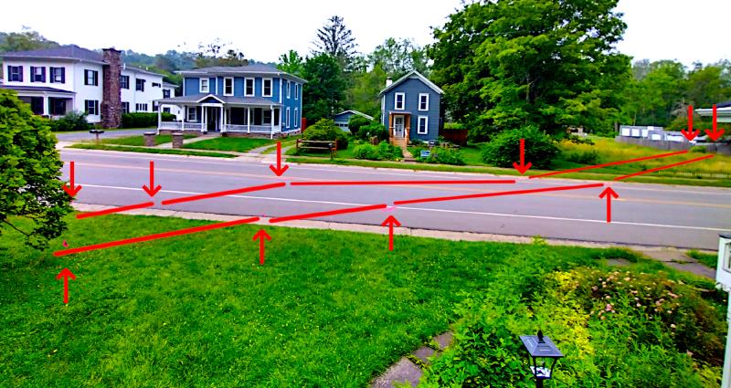
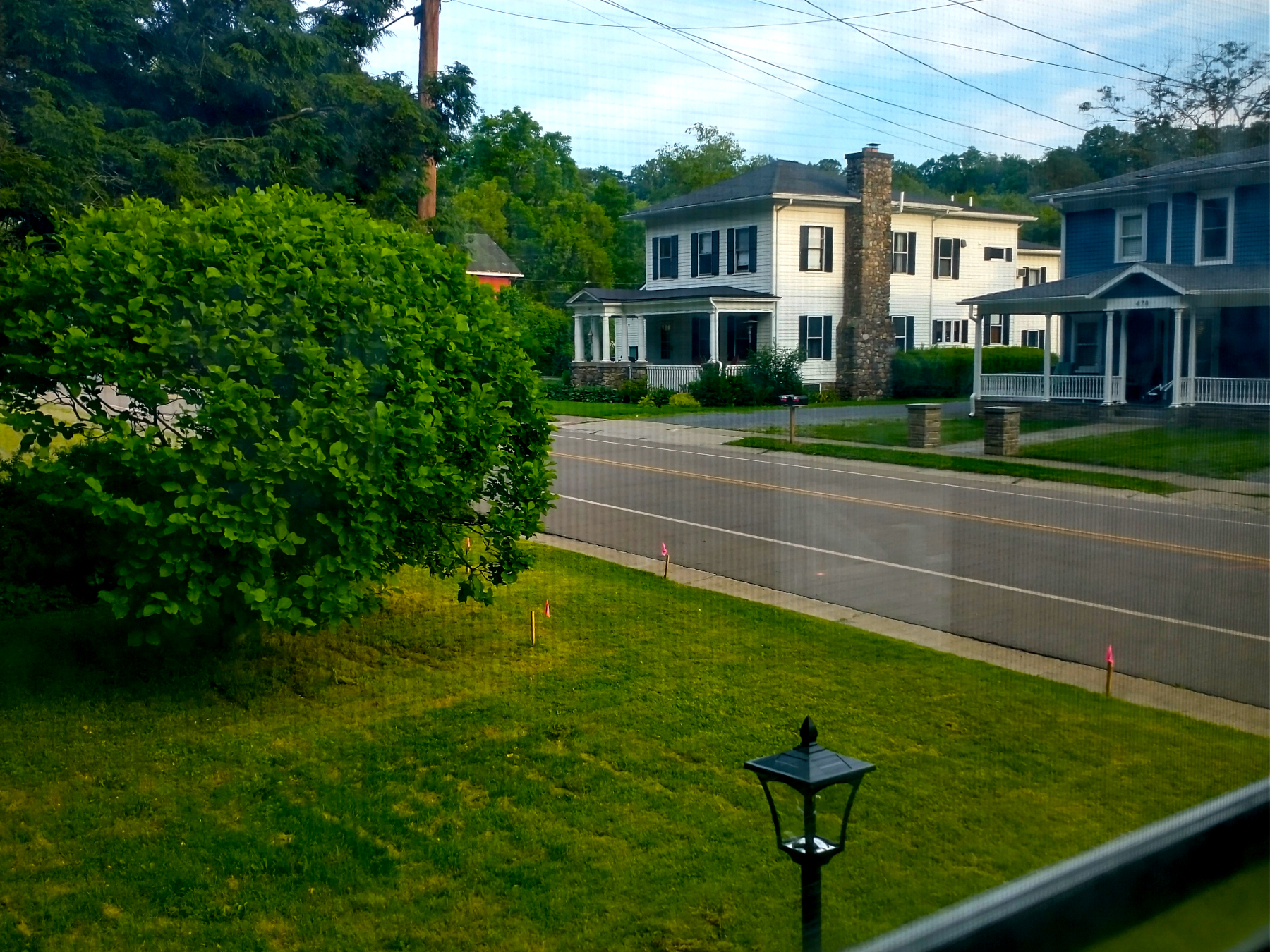
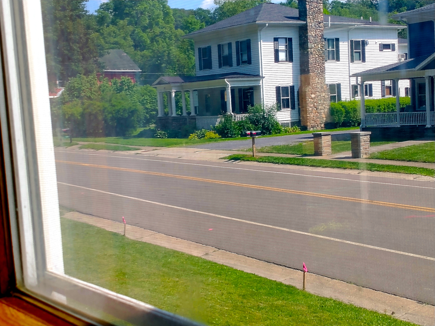
And to get a better sense of how Emily would have experienced the Mill Race Bridge, I offer the following photographs viewing it from the windows of her home. (The photographs show reflections on the windows and the window screens are also apparent.)

— 06 Jul 2023, Adam Smith. View largest available size.

— 06 Jul 2023, Adam Smith. View largest available size.

— 06 Jul 2023, Adam Smith. View largest available size.
— 06 Jul 2023, Adam Smith. View largest available size.
A KMZ export (Keyhole Markup Language Zipped) of the GPS encoded data captured by the ground penetrating radar scans can be downloaded here. This KMZ projected onto Google Maps:
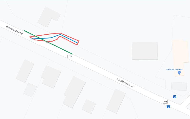
— 29 Jun 2023, KML export from Ground Penetrating Radar Systems scans, overlaid on Google Maps, traffic layer. View largest available size.

— 29 Jun 2023, KML export from Ground Penetrating Radar Systems scans, overlaid on Google Maps, satellite layer. View largest available size.
— 29 Jun 2023, KML export from Ground Penetrating Radar Systems scans, overlaid on Google Maps, satellite layer. View largest available size.
Dowsing
Mike Bishop, the ground penetrating radar technician suggested walking with a “divining rod” to further corroborate the results of the ground penetrating radar, and of course, I was curious. While he admitted that it was a questionable practice, he claimed that it is actually used widely in oil drilling and other domains. It had been raining in the days prior, and he reasoned that the compacted earth of the raceway, filled with rocks, would be a likely channel for water still.
As I write this, dowsing/divining has long been considered a pseudo-science. It is my understanding that it has not been replicated in controlled scientific tests.
The scientific explanation for what happens when people dowse is that “ideomotor movements” – muscle movements caused by subconscious mental activity – make anything held in the hands move. It looks and feels as if the movements are involuntary. The same phenomenon has been shown to lie behind movements of objects on a Ouija board.
– 29 July 2009, Why Dowsing Makes Perfect Sense by Michael Brooks, NewScientist.com.
The rod he used was from a “pin flag” identical to the ones used to mark where he had painted the edges of the raceway, as seen in the photographs of the event. The flag had been removed and the rod bent at a ninety degree angle, one side significantly shorter than the other. He walked along the northern edge of Brooktondale Road, from west to east going in the direction of Mills’ Store, holding the shorter side of the bent rod in his closed right hand in front of him, the rod pointed east parallel to the road. As he crossed the previously detected and marked western edge, the rod began to turn, and by the time he reached the mid point between the two detected edges, the rod had turned fully toward the south and then the southwest, the detected course of the raceway, seemingly verifying what the GPR had detected.
I asked if I could try, and after brief instruction, I replicated his process described above, and with similar results. I must admit that I only walked from a point several feet west of the western edge detected to a point several feet east of the eastern point detected, but as I crossed the western edge, the rod began to waver, and as I approached the center of the supposed raceway, it swung very definitively to the south and then the southwest as I continued. It certainly seemed to me as though the rod had moved on its own without my influence. If nothing else, it was an amusing episode.
The Barn
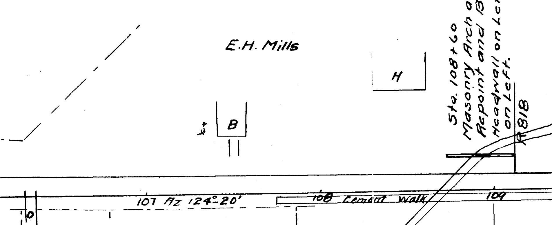
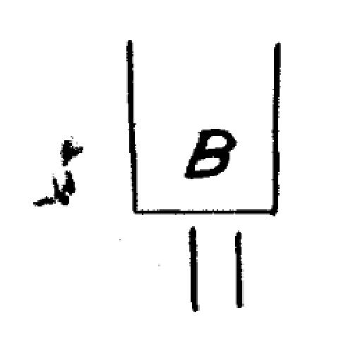
Another question I often wondered was where the Mills kept horses and/or carriage that they would presumably have owned. The 1912 highway map provides the only evidence of which I am aware that depicts a barn, indicated with a “B” on the map, that presumably was the structure that housed these.
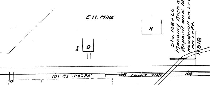
— 26 Feb 1912, Plans for Improving the Cooks Corners-Brookton: Slaterville Springs-Caroline County Highway, Instrument number BF033282-001, Sheet 5, Tompkins County Clerk, Ithaca NY. Cropped. View largest available size.
There appears to be a symbol of some kind next to the structure that I have yet to be able to identify.
— 26 Feb 1912, Plans for Improving the Cooks Corners-Brookton: Slaterville Springs-Caroline County Highway, Instrument number BF033282-001, Sheet 5, Tompkins County Clerk, Ithaca NY. Cropped. View largest available size.
H is House, and B is Barn, (some barns are the modern “garage” and not what some think of as a barn). The mark next to the barn is puzzling, the rest of the map is fairly clean, and there are some other symbols above “John Manderville” at stations 93, 94, 94+75, & 95. So, I would guess that this mark is trying to show something but not sure what, maybe a spring?
When looking at any map you must take into consideration what the map is intended for even though it may show additional information (even ones today such as GIS maps vs Survey maps, Boundary vs Site Plan or Topo) and the level of accuracy in the tools available at the time and the care of the ones using them.
— 17 Feb 2023, Ian Sheive, Sheive Land Surveying, personal correspondence.
John Mandeville is explored further in other sections of this material, but it should be noted that he was known to have consulted on the 1912 highway surveys for Creek (Brooktondale) Road that indicate the barn at that time.
This barn falls within an area that was later appropriated in the 1960’s, and presumably any structure that remained at that time would have been demolished.

— 30 Sep 1963, Appropriation Map, Map Drawer 545, Instrument Number BF162398-001, Tompkins County Clerk, Ithaca NY. Cropped. View largest available size.
I also had the indicated area scanned by ground penetrating radar on 29 Jun 2023, presuming that there might remain buried pieces of a stone foundation, or some kind of soil disturbance or compaction where the barn stood. In that area, there was something detected that was different from the surrounding ground, but nothing definitive could be determined.
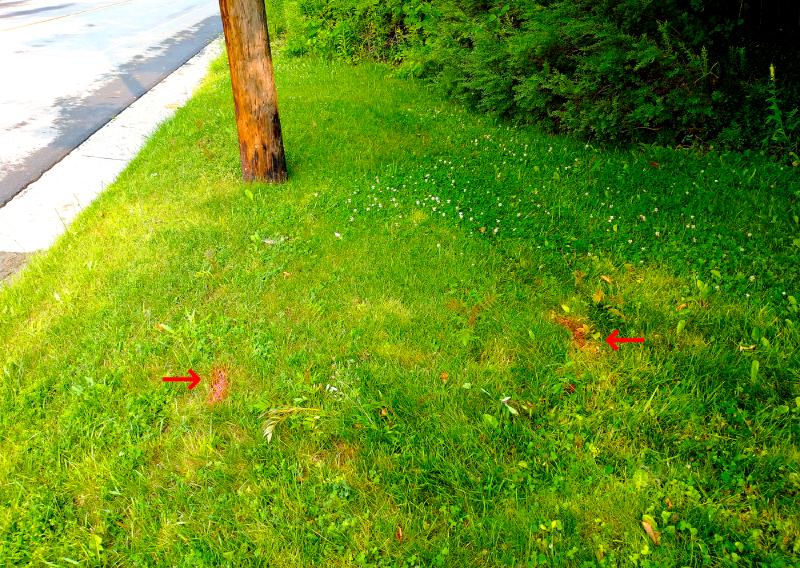
— 29 Jun 2023, Adam Smith. View largest available size.
— 29 Jun 2023, Adam Smith. View largest available size.
The equipment and methods used did not detect reactions from potential barn foundations
— 29 Jun 2023, Ground Penetrating Radar Systems Report for 475 Brooktondale Road, p2.
Perhaps a future owner of Mills’ Home will try again to locate these structures using better non-invasive technology, more sensitive and more accurate, and perhaps that person will approach the endeavor with a better understanding of what they are looking for, and where, than I have been able to acquire myself.
The Mill Race Bridge as a Property Landmark
The goal of this section is to correctly interpret the two Mills’ Home deed descriptions from the 1800’s. These descriptions described the property for more than two decades after Emily died.
As the documents that follow will show, Brooktondale Road’s previous names and designations included: Creek Road, Cooks Corners-Brookton Highway, Brooktondale-Ithaca Highway, New York State Route 330, and Tompkins County Route No. 115.
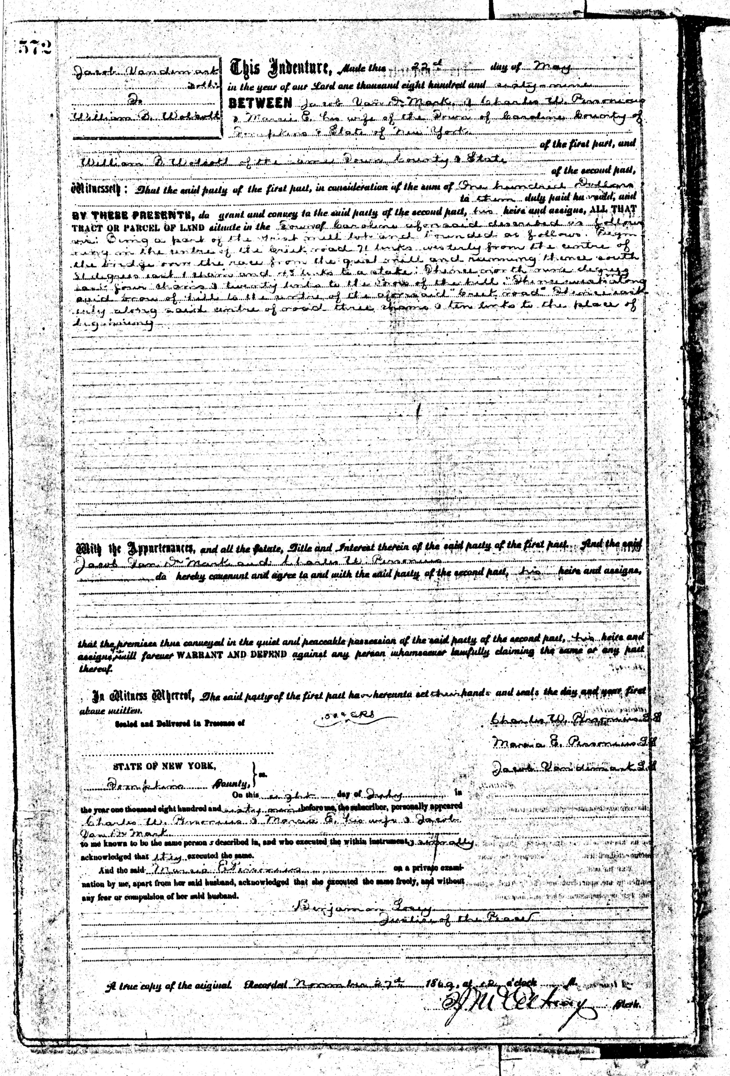
The first deed for Mills’ Home as a separate parcel divided from the grist mill lot, was given to William Benton Wolcott in 1869, and was appropriately called “The Wolcott Lot” at the time. The Tompkins County Clerks Office was kind enough to provide me with two scans of the deed that I present here as each is clearer in areas that the other is not:
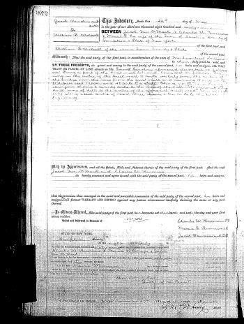
— 22 May 1869, Jacob Vandemark, Charles W. Personius & Marcie E. his wife to William B. Wolcott, Caroline Deeds Book 1, p572, Tompkins County Clerk, Ithaca NY. View largest available size.
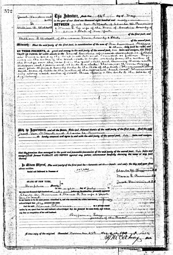
— 22 May 1869, Jacob Vandemark, Charles W. Personius & Marcie E. his wife to William B. Wolcott, Caroline Deeds Book 1, p572, Tompkins County Clerk, Ithaca NY. Alternate scan provided by Tompkins County Clerk, with contrast enhanced. View largest available size.
The transcribed legal property description:
Being a part of the grist mill lot and bounded as follows. Beginning in the center of the Creek road, 71 links westerly from the center of the bridge over the race from the grist mill and running thence south 81 degrees east 1 chain and 43 links to a stake; thence north nine degrees east, four chains & twenty links to the brow of the hill. Thence westerly along said brow of hill to the center of the aforesaid “Creek road”. Thence easterly along said center of road three chains & ten links to the place of beginning.
This and subsequent deed deed descriptions use the metes and bounds system and quadrantal compass bearings.
Prior to the Revolutionary War, when land was surveyed, the “metes and bounds” system was used to define boundaries. The system is still in existence today for land which was acquired before the present system of surveying land was adopted. States which used this form of surveying were the thirteen original colonies (Connecticut, Delaware, Georgia, Maryland, Massachusetts, New Hampshire, New Jersey, New York, North Carolina, South Carolina, Pennsylvania, Rhode Island, Virginia) as well as the state land states Hawaii, Kentucky, Maine, Texas, Tennessee, Vermont, West Virginia and parts of Ohio.
In a metes and bounds land description, there is a starting point which is always at a corner. This is followed by directions and measurement which may be written in a variety of ways, indicating a line leading to the next corner. The corners will generally be a physical feature. Often the property owners will be mentioned who bound the land being described.
— Metes and Bounds, familysearch.org. Emphasis added.
In conjunction with using landmarks as boundaries, it seems to have been common practice to measure landmarks from their centers, presumably to choose a more stable reference point, thus mitigating variations over time, such as the growth of trees, the widening of roads, etc. In the Mills’ Home deeds and surveys, this practice is used in relation to Brooktondale Road, the mill race bridge, and the large oak tree on the hill. The references to the center of the road are implicit in the Mills’ Home deeds, but explicit in the corresponding Dalebrook deed descriptions.
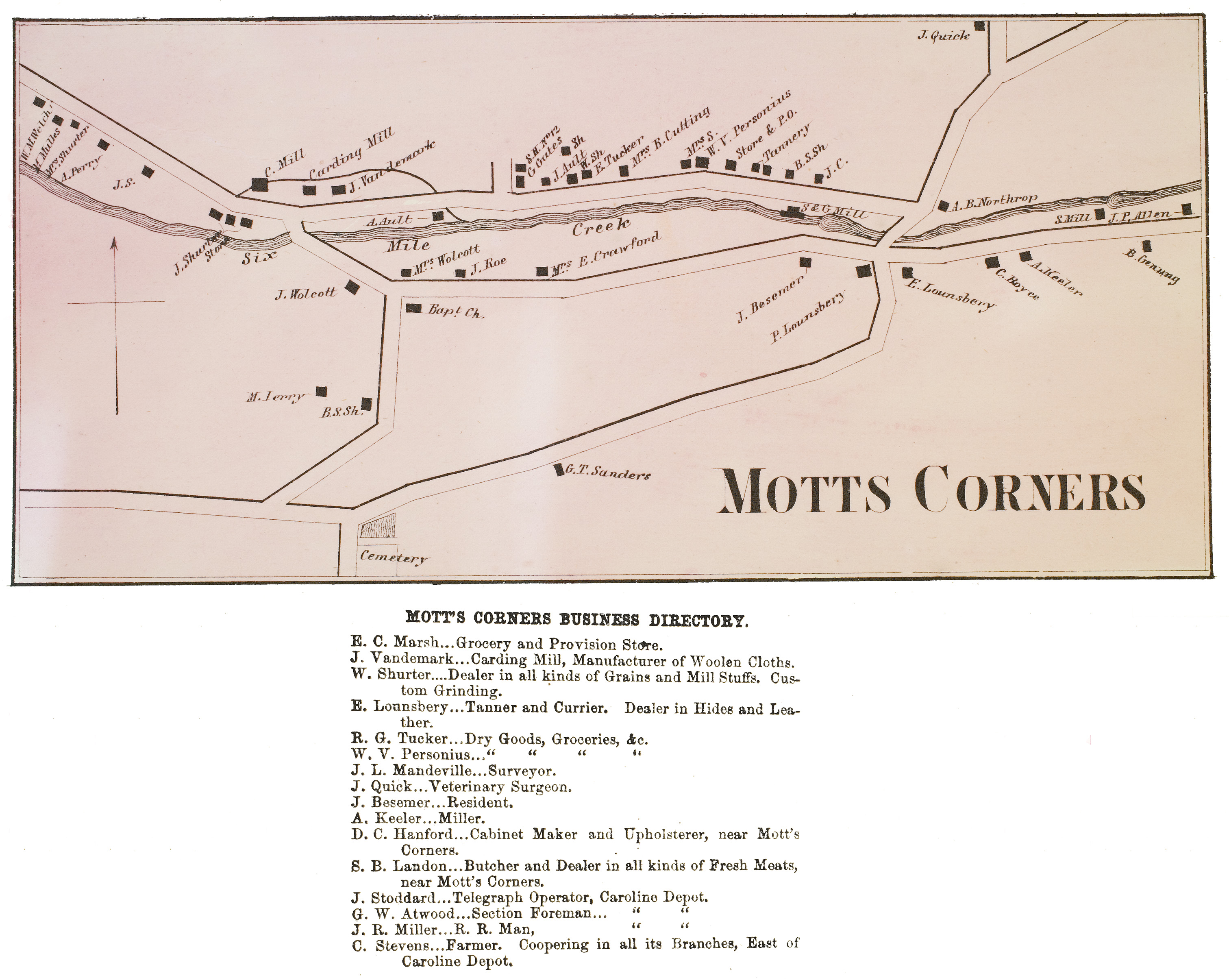
Although I do not see the name of the surveyor in 1869 documented, it was likely John L. Mandeville (1836 to 29 Nov 1907), the grandson of Reverend Garrett Mandeville (18 May 1775 to 11 Dec 1853), who was the minister of the Dutch Reformed Church for 25 years. John Mandeville was a Civil War veteran and a founding member of the Congregational Church of Mott’s Corners. He is listed as “surveyor” on the 1866 Stone & Steward map of Mott’s Corners, a portion of which was shown above, and he advocated for and consulted on the 1912 highway improvements already explored above, although he died before he could see the work completed. For more information, see John Mandeville and The Good Roads Movement. Obviously, I can’t prove that John Mandeville was the 1869 surveyor, but for the purposes of this exploration, I will suppose that he was.
With the next Mills’ Home deed in 1883, a new Place of Beginning relative to the Mill Race Bridge was established, and this description remained unchanged until Jessie Brewer sold the property to the Jones family. The difference in measurement suggests the surveyor of 1883 may have been someone other than the surveyor of 1869. But as I will show, without this new Place of Beginning, we would not know how to correctly interpret these deed descriptions.
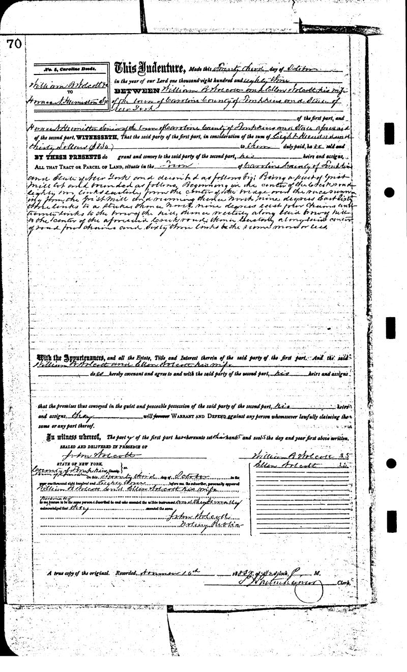
— 23 Oct 1883, William B. Wolcott to Horace N. Humiston senior, Caroline Deeds Book 5, p70, Tompkins County Clerk, Ithaca NY. View largest available size.
The transcribed property description:
Being a part of the grist mill lot and bounded as follows. Beginning in the center of the Creek road, eighty-two links easterly from the center of the bridge crossing the mill race; running thence north nine degrees east, sixty-three links to a stake; thence north nine degrees east, four chains and twenty links to the brow of the hill; thence westerly along said brow of hill to the center of the aforesaid Creek Road; thence easterly along said center of road four chains and sixty-three links to the place of beginning.
To understand the measurements given in the descriptions above:
The chain is a unit of length equal to 66 feet (22 yards), used in both the US customary and Imperial unit systems. It is subdivided into 100 links or 4 rods. There are 10 chains in a furlong, and 80 chains in one statute mile. In metric terms, it is 20.1168 m long. By extension, chainage (running distance) is the distance along a curved or straight survey line from a fixed commencing point, as given by an odometer.
— Chain (unit), Wikipedia.org.
The link (usually abbreviated as “l.”, “li.” or “lnk.”), sometimes called a Gunter’s link, is a unit of length formerly used in many English-speaking countries. In US customary units modern definition, the link is exactly 66⁄100 of a US survey foot, or exactly 7.92 inches or approximately 20.12 cm.
— Link (unit), Wikipedia.org.
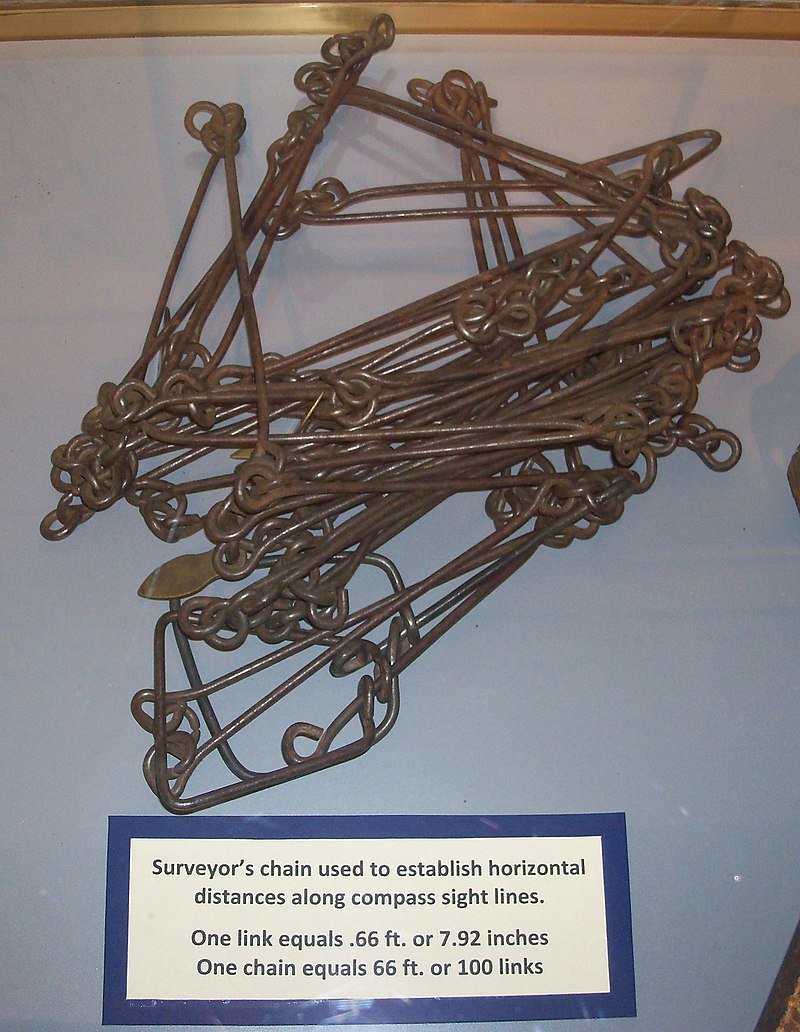
These measurements were taken by a standardized physical chain with 100 links called a Gunter’s chain.

Surveyor’s chain used to establish horizontal distances along compass sight lines.
One link equals .66 ft. or 7.92 inches
One chain equals 66 ft. or 100 links
— 25 Aug 2010, public domain image, attached to Gunter’s chain article at Wikipedia.org. View largest available size.
Gunter’s chain (also known as Gunter’s measurement) is a distance measuring device used for surveying. It was designed and introduced in 1620 by English clergyman and mathematician Edmund Gunter (1581–1626). It enabled plots of land to be accurately surveyed and plotted, for legal and commercial purposes.
…Gunter’s chain reconciled two seemingly incompatible systems: the traditional English land measurements, based on the number four, and decimals based on the number 10. Since an acre measured 10 square chains in Gunter’s system, the entire process of land area measurement could be computed using measurements in chains, and then converted to acres by dividing the results by 10.[2] Hence 10 chains by 10 chains (100 square chains) equals 10 acres, 5 chains by 5 chains (25 square chains) equals 2.5 acres. By the 1670s the chain and the link had become statutory units of measurement in England.
— Gunter’s chain, Wikipedia.org.
The 1869 and 1883 deed descriptions follow the same structure in five steps, the significant differences between them emphasized in the following step-wise comparison:
| 1869 | 1883 | ||
|---|---|---|---|
| 1 | Beginning in the center of the Creek road, 71 links westerly from the center of the bridge over the race from the grist mill | 1 | Beginning in the center of the Creek road, eighty-two links easterly from the center of the bridge crossing the mill race; |
| 2 | running thence south 81 degrees east 1 chain and 43 links to a stake; | 2 | running thence north nine degrees east, sixty-three links to a stake |
| 3 | thence north nine degrees east, four chains & twenty links to the brow of the hill. | 3 | thence north nine degrees east, four chains and twenty links to the brow of the hill; |
| 4 | Thence westerly along said brow of hill to the center of the aforesaid “Creek road”. | 4 | thence westerly along said brow of hill to the center of the aforesaid Creek Road; |
| 5 | Thence easterly along said center of road three chains & ten links to the place of beginning. | 5 | thence easterly along said center of road four chains and sixty-three links to the place of beginning. |
I am currently working on software to draw accurate survey maps based on these deed descriptions, at which point, I will be able to overlay them onto the current survey to estimate where the mill race bridge center was.
John Mandeville and The Good Roads Movement
John L. Mandeville was first cousins with Dr. Martin Besemer. John’s mother, Almira A. (Hutchinson) Mandeville (06 Mar 1810 to 06 Apr 1885) is the sister of Dr. Besemer’s mother Joanna (Hutchinson) Besemer (02 Sep 1812 to 19 Jun 1853).
Although I do not see the name of the surveyor in 1869 documented, it was likely John L. Mandeville (1836 to 29 Nov 1907), the grandson of Reverend Garrett Mandeville (18 May 1775 to 11 Dec 1853), who was the minister of the Dutch Reformed Church for 25 years. John Mandeville was a Civil War veteran and a founding member of the Congregational Church of Mott’s Corners. He is listed as “surveyor” on the 1866 Stone & Steward map of Mott’s Corners, a portion of which was shown above:
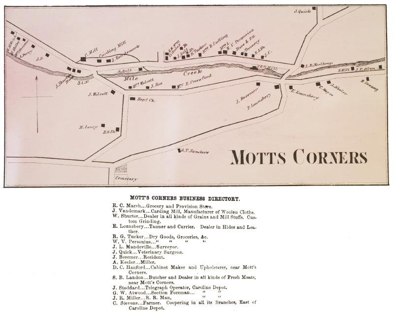
MOTT’S CORNERS BUSINESS DIRECTORY.
E. C. Marsh…Grocery and Provision Store.
J. Vandemark…Carding Mill, Manufacturer of Woolen Cloths.
W. Shurter….Dealer in all kinds of Grains and Mill Stuffs. Custom Grinding.
E. Lounsbery…Tanner and Currier. Dealer in Hides and Leather.
R. G. Tucker…Dry, Goods, Groceries, &c.
W. V. Personius…Dry, Goods, Groceries, &c.
J. L. Mandeville…Surveyor.
J. Quick…Veterinary Surgeon.
J. Besemer…Resident.
A. Keeler…Miller.
D. C. Hanford…Cabinet Maker and Upholsterer, near Mott’s Corners.
S. B. Landon…Butcher and Dealer in all kinds of Fresh Meats, near Mott’s Corners.
J. Stoddard…Telegraph Operator, Caroline Depot.
G. W. Atwood…Section Foreman…Caroline Depot.
J. R. Miller…R. R. Man, Caroline Depot.
C. Stevens…Farmer. Coopering in all its Branches, East of Caroline Depot.
— 1866, Photographic Atlas of Tompkins County, New York. Stone & Stewart, Philadelphia, p21. View largest available size.
By 1865 the Town of Caroline had declined from a peak population of 2,644 to 2,257. Motts Corners, Slaterville, Caroline Center, and Speedsville were significant enough to deserve village maps in the 1866 Atlas. Motts Corners was the largest of these settlements, with a population of three hundred.
— Molly Adams, “Town of Caroline” in The Towns of Tompkins County: From Podunk to the Magnetic Springs edited by Jane Marsh Dieckmann, p55.
Interestingly, John Mandeville advocated for the improved road depicted in the 1912 highway surveys, and he consulted with the surveyors on that project, although he did not live to see it constructed.
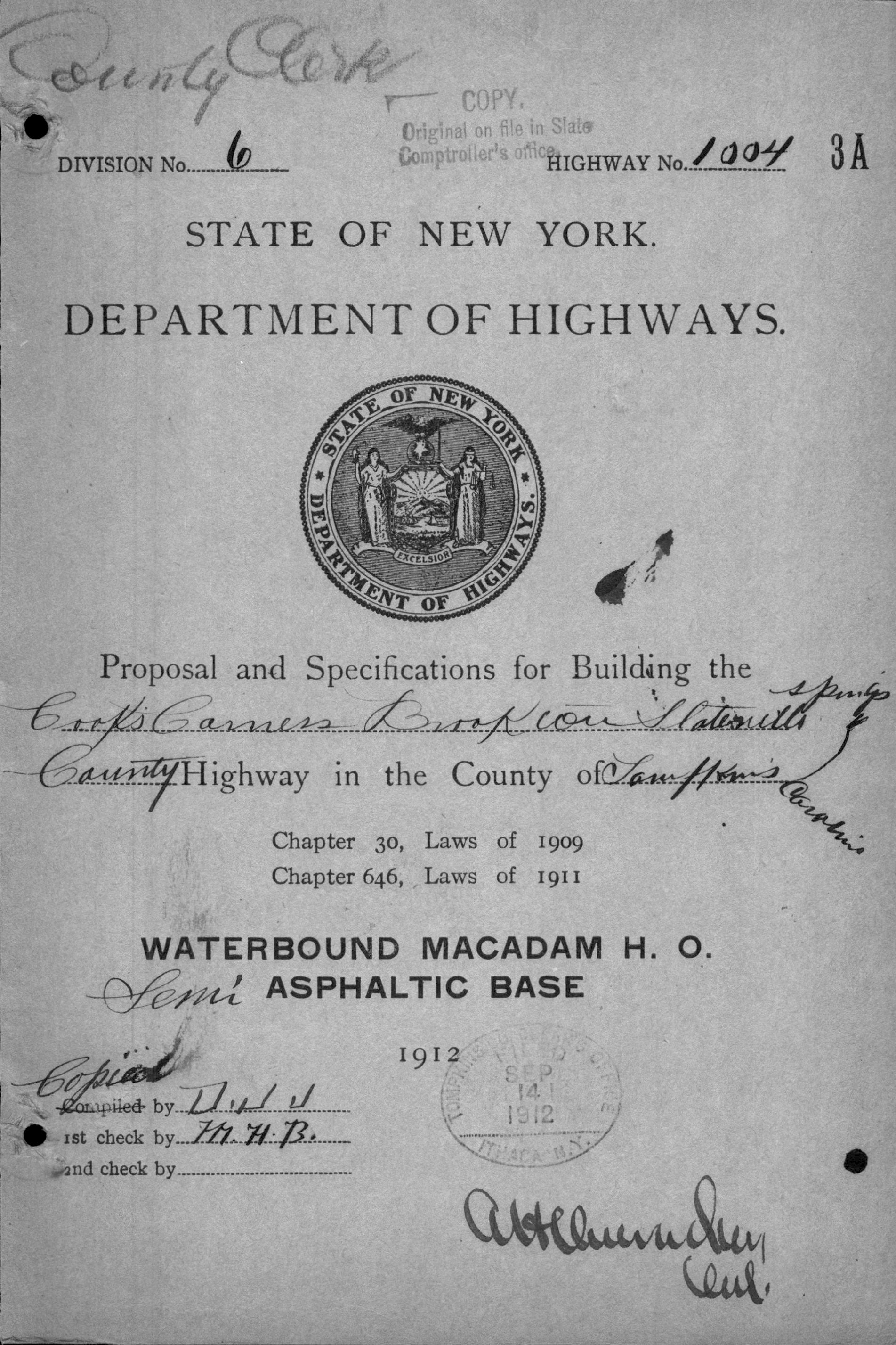
John “Good Roads” Mandeville went to Scotland to study the macadam process before designing the road through Brookton in 1912.
— Molly Adams, “Town of Caroline” in The Towns of Tompkins County: From Podunk to the Magnetic Springs edited by Jane Marsh Dieckmann, p61.

— 17 Jun 1912, Proposal and Specifications for Building the Cook’s Corners Brookton, Slaterville Springs Highway in the County of Tompkins, Caroline, Tompkins County Clerk, Ithaca NY. View largest available size.
The Good Roads Movement occurred in the United States between the late 1870s and the 1920s. It was the rural dimension of the Progressive movement. A key player was the United States Post Office Department. Once a commitment was made for Rural Free Delivery of the mail, the Post Office had to determine which local roads were suitable and which were not. Farmers living on officially unusable roads now had motivation to get them upgraded. Advocates for improved roads turned local agitation into a national political movement. It started as a coalition between farmers’ organizations groups and bicyclists’ organizations, such as the League of American Wheelmen. The goal was state and federal spending to improve rural roads. By 1910, automobile lobbies such as the American Automobile Association joined the campaign, coordinated by the National Good Roads Association.
Outside cities, roads were dirt or gravel; mud in the winter and dust in the summer. Travel was slow and expensive. Early organizers cited Europe where road construction and maintenance was supported by national and local governments. In its early years, the main goal of the movement was education for road building in rural areas between cities and to help rural populations gain the social and economic benefits enjoyed by cities where citizens benefited from railroads, trolleys and paved streets. Even more than traditional vehicles, the newly invented bicycles could benefit from good country roads.
— Good Roads Movement, Wikipedia.org.
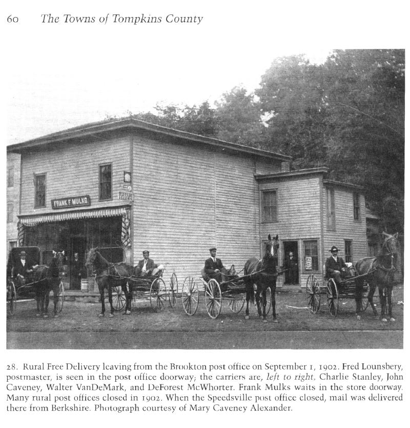
The first day of Rural Free Delivery of mail on 01 Sep 1902 is captured by one of the best known photographs of Mulks’ Store, present-day Brookton’s Market:
60 The Towns of Tompkins County
- Rural Free Delivery leaving from the Brookton post office on September 1, 1902. Fred Lounsbery, postmaster, is seen in the post office doorway; the carriers are, left to right, Charlie Stanley, John Caveney, Walter VanDeMark, and DeForest McWhorter. Frank Mulks waits in the store doorway. Many rural post offices closed in 1902. When the Speedsville post office closed, mail was delivered there from Berkshire. Photograph courtesy of Mary Caveney Alexander.
— Molly Adams, “Town of Caroline” in The Towns of Tompkins County: From Podunk to the Magnetic Springs edited by Jane Marsh Dieckmann, p60. View largest available size.
During the 19th century, cities usually had decent roads, but rural roads were often little more than muddy trails. Bicyclists and railroad companies began calling for good roads in the 1880s, but American road building really took off in the 20th century as a response to rising numbers of cars and trucks.
— Better Roads, americanhistory.si.edu.
A majority of Americans still lived in rural areas in the early twentieth century, but operating a motor vehicle there was nearly impossible because of poor-quality—or nonexistent—roads. Consequently, most vehicles were purchased by people living in cities, where streets were paved. Roads in rural areas served primarily as feeders into train stations. A few miles from stations, roads would terminate at streams or county lines or simply disappear into the mud. The cost of hauling grain ten miles from farm to station by road was higher than the cost of hauling it five hundred or one thousand miles by train to big-city markets. It could take an entire day to travel twenty miles in a rural area.
— Roads, Encyclopedia.com.
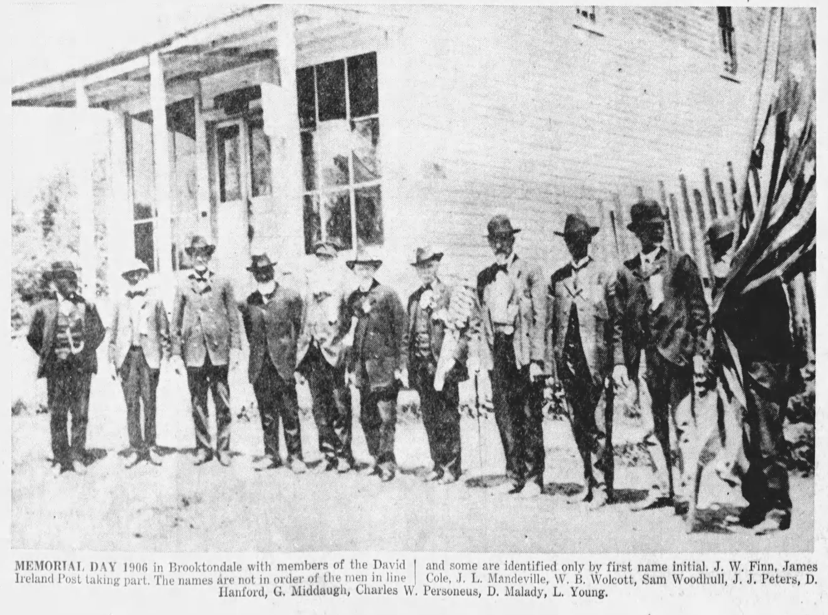
John Mandeville along with William B. Wolcott and Charles Personius were photographed with other GAR members in 1906, in front of Personius Hall.

— 19 Dec 1959, The Ithaca Journal, Ithaca NY, p12, newspapers.com. Emphasis added.View largest available size.
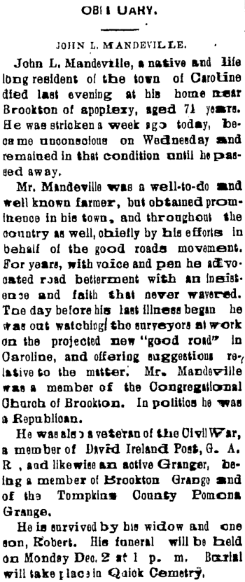
OBITUARY
JOHN L. MANDEVILLE.
John L. Mandeville, a native and life long resident of the town of Caroline died last evening at his home near Brookton of apoplexy, aged 71 years. He was stricken a week ago today, became unconscious on Wednesday and remained in that condition until he passed away.
Mr. Mandeville was a well-to-do and well known farmer, but obtained prominence in his town, and throughout the country as well, chiefly by his efforts in behalf of the good roads movement. For years, with voice and pen he advocated road betterment with an insistence and faith that never wavered. Tuesday before his last illness began he was out watching the surveyors at work on the projected new “good road” in Caroline, and offering suggestions relative to the matter. Mr. Mandeville was a member of the Congregational Church of Brookton. In politics he was a Republican.
He was also a veteran of the Civil War, a member of David Ireland Post, G. A. R., and likewise an active Granger, being a member of Brookton Grange and of the Tompkins County Pomona Grange.
He is survived by his widow and one son, Robert. His funeral will be held on Monday Dec. 2 at 1 p.m. Burial will take place in Quick Cemetery.
— 30 Nov 1907, Ithaca Daily Journal, Ithaca NY, p3, nyshistoricnewspapers.org. View largest available size.
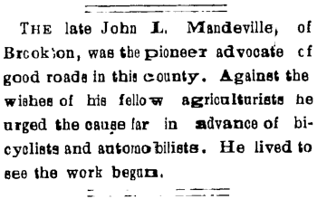
The late John L. Mandeville, of Brookton, was the pioneer advocate of good roads in this county. Against the wishes of his fellow agriculturist he urged the cause far in advance of bicyclists and automobilists. He lived to see the work begun.
— 05 Dec 1907, Ithaca Daily Journal, Ithaca NY, p4, nyshistoricnewspapers.org. View largest available size.